Pete's Walks - The Chiltern Way
If you are considering walking this route yourself, please see my disclaimer. You may also like to see these notes about the maps and GPX files.
Day 11 27/6/05 Flaunden to Gorelands Lane (Chalfont St Giles) (7.3 miles each way)
Parked in road in Flaunden.
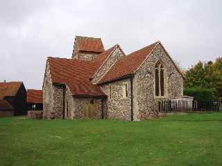
Sarratt church 26/10/05
This was an absolutely delightful walk, through wonderful countryside on a beautiful day. The temperature was in the low-mid 20’s all day, and there was hardly a cloud in the sky. The first few miles passed through fields, mainly grass, and crossed two or three lanes, before reaching Sarratt church (where there was a flower sale on). As I got close to the church, marvellous views opened up of the Chess valley. There was then a steep descent (steepest on whole route so far) through a field (occupied by cows) to the river Chess. This section of the Chess valley was a nature reserve, with a board explaining what birds and other wildlife could be seen there. The way then lead through woods up a gradual incline on the other side of the valley to reach Chenies. Having crossed the busy A404, a green lane led gradually downhill and under a railway bridge into more woodland (the only beech wood I’d seen so far, other than Sharpenhoe Clappers) and then down a farm track between horse paddocks into Chorleywood West. After almost a mile through the expensive houses of this strange mix of commuter suburb and rural village, a green lane followed by a path led through a long section of woodland (some owned by the Woodland Trust). Finally, a path led across a large meadow to the entrance to the University of Buckingham campus on Gorelands Lane (it was also close to the Chiltern Open Air museum, which I’d liked to have visited but didn’t have time to do it justice). The return journey was just as enjoyable, with some different views of the gorgeous countryside.
Total distance: 79.8 miles (each way)