Pete's Walks - The Hertfordshire Way
If you are considering walking this route yourself, please see my disclaimer. You may also like to see these notes about the maps and GPX files.
Day 5 18/10/05 Whitwell to Wheathampstead (8.2 miles each way)
Parked in recreation ground car park in Whitwell.
Note: in case you are wondering, the two week gap between the last walk and this was because I rested for a week before going on a week’s walking holiday in the Lake District with some friends.
Note: Sorry, you can't enlarge the photos on this page. I must have accidentally deleted the originals at some point!
When I got to the car park at Whitwell, there were three men there who were obviously about to go on a walk themselves (the walking boots and map cases gave the game away!). I got chatting to them, and it turned out that they had walked the Hertfordshire Way twice and also walked the Chiltern Way. They said that the Hertfordshire Way wasn’t as good as the Chiltern Way, which was what I expected, and that the least interesting section of the Hertfordshire Way was between Radlett and Potter’s Bar (which again didn’t surprise me too much). It was nice to talk to them, as they are the first people I’ve met who have done any of the walks I’ve been doing.
From Whitwell, the Hertfordshire Way led across a sequence of fields. Although some had been recently ploughed, the footpath had been reinstated (marked out by tractor tracks) and was obviously quite well used. There were some nice views of the rolling hills and valleys in this area [1]. Having passed a barn and a house, I crossed a lane to a stile and went across two pastures. The path continued beside a small wood, and then descended across another pasture, to a drive that shortly crossed an old and elaborately decorated bridge – the guide book says that this area was once the parkland of a great house, and that under the bridge is the dried-out remains of an ornamental pond.
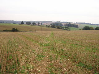
[1] Looking back along the Hertfordshire Way from near Whitwell
At the end of the drive, I turned right and almost immediately took a bridleway on the right. This led along a farm track between fields to reach a lane, which I followed for about a hundred yards before turning left onto another bridleway (hedged on both sides). When this reached a wood, I took a smaller path off to the left, which rose briefly to the edge of the wood, where a stile led onto a sequence of three pastures. A short lane walk and then a fenced path between pastures led to the village of Codicote.
I followed the main road through the village for about a quarter of a mile, before turning right and then taking a footpath on the right. This led past a school and then continued between hedges or fences, descending a flight of steps to reach a farm track, then down more steps to reach a lane. I followed the lane to the left, turning left at Codicote Bottom Farm, and then took a clear track on the right that took me to Ayot St Lawrence. I made a slight detour here to look at Shaw’s Corner, the home of George Bernard Shaw for many years (now owned by the National Trust). The village also has a ruined mediaeval church [2], and a ‘new’ church [3] built in the eighteenth century in the classical Greek style – it looks more like a temple than a church. Having followed a footpath to the new church, I turned left along a lane, and then the Hertfordshire Way turned left down a long fenced path between pastures. Eventually it reached a drive and then branched left onto a track (with a golf course on the left).
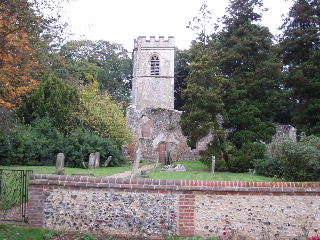
[2]The old church in Ayot St Lawrence
I have generally found the Hertfordshire Way guide to not be quite as good as the one I had for the Chiltern Way – it is shorter and less detailed, not mentioning every path junction or crossing along the route. I found the description for this small section of the route particularly terse – if the Hertfordshire Way hadn’t been well waymarked on the ground, I don’t think I’d have found the path from the description in the guide book.
After a quarter of a mile or so, a gate on the left gave access to the golf course, where a sequence of well-marked paths led across the course in front of the club house. The last waymark was a little unclear, but I found the gate giving exit to the course, and followed a field edge path to a road. Across the road a track led downhill, passing under a bridge carrying the Wheathampstead bypass and then crossing a ford of the river Lea. Finally a lane led to a main road on the edge of Wheathampstead.
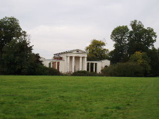
[3]The 'new' church in Ayot St Lawrence
The walk back to Whitwell was pleasant but uneventful. I stopped for lunch around 1.30, sitting on a bench in front of the ruined church in Ayot St Lawrence. As I got back to Codicote, I met a man with two dogs. He told me that one, much the friendlier of the two, was part-wolf, and it was obviously true from its shape and colouring. He said that they are so friendly and docile, that they are used as ‘petting dogs’ in hospitals, where making friends with animals helps people recover.
The skies were quite grey today, with the odd bit of sunlight shining through. It stayed dry all day, but was quite cool – I wore my fleece all day, but sometimes had it unzipped and occasionally thought of taking it off.
Total Distance: 38.7 miles each way