About the Two Ridges Link
The Two Ridges Link is an 8-mile walk that connects the eastern end of the Ridgeway at Ivinghoe Beacon with the start of the Greensand Ridge Walk at Linslade (near Leighton Buzzard). The route is indicated by signposts and waymarks, and is also marked on the latest OS Explorer map.
Just over a third of the Two Ridges Link follows the towpath of the Grand Union Canal, before it turns on to field paths and bridleways, passing through the villages of Slapton and Ivinghoe Aston before a steep climb to the top of Ivinghoe Beacon.
Buckinghamshire County Council publishes a leaflet describing the Two Ridges Link, which can be ordered from their web site (see my links page). Most of the historical or other factual data that I quote in my journal is taken from this source. The route is also shown on OS Explorer maps 181 and 192.
About my walk
I walked the Two Ridges Link in both directions, thus making a 16-mile walk which is the sort of distance I like to cover in a day. I started in Linslade, walked to Ivinghoe Beacon, and returned.
It may seem odd to write a journal for a walk that only took one day. However, the Two Ridges Link is an official path, connecting two others, and so I decided to include it in my journals. This journal may be of interest to anybody else thinking of walking the Two Ridges Link. The walk could feasibly be used by someone wishing to do a combined walk of the Ridgeway and the Greensand Ridge Walk.
Click here to see a very rough map of the Two Ridges Link (but only if you have already read my disclaimer and notes regarding maps).
A note about the photographs: I didn't have a camera with me on this walk, as I didn't decide to create a web site until much later. So I drove round several months afterwards to take some photo's to add to the journal on the site. As in all such cases where the photo's were taken at a later date I have added the date to the captions below the photographs.
Day 1 26/08/05 Linslade to Ivinghoe Beacon (8 miles each way)
Parked in car park in Leighton Buzzard (I got a parking ticket through stupidly misinterpreting a sign and thinking parking was free! My confusion was partly caused by a ticket machine that wasn’t working).
From the car park in the centre of Leighton Buzzard, it was a pleasant 10-minute stroll through the attractive town centre to the canal at Linslade. I stopped briefly to read a notice board about the Greensand Ridge Walk, before heading southwards along the canal towpath. As I walked along the towpath, I passed a few narrow boats moored to the bank (I noticed on the way back that one was flying a ‘Jolly Roger’!), and saw one or two more actually travelling along the canal. I also passed an occasional angler. The canal went under a wide modern bridge carrying the new dual-carriageway road to Aylesbury, and a short while later came to a lock, where there was a pub on the opposite bank (looked surprisingly busy when I returned this way about 2.30, but then this was Friday lunchtime).
I’m not really that fond of walking along canal towpaths myself – they’re OK for a short while, but they are flat by definition and were created for functional rather than recreational purposes, so I don’t find them too interesting to walk along for too great a time. One of my friends actually goes on holiday to walk towpaths, so some people obviously enjoy them (mind you, he’s also a self-confessed train-spotter!). Anyway, I didn’t find this part of the walk too inspiring – not unpleasant, but flat and somewhat monotonous. The only variety came at the next lock, where the towpath changed from the east bank to the west bank – there was a double-arched bridge here, as in 1839 some of the locks were doubled to increase the speed of traffic (the second locks are now filled in). A mile or so later, I came to another bridge carrying a farm track and here the Two Ridges Link finally left the Grand Union Canal.
Having crossed the bridge, I walked through a large field which I discovered was occupied by bullocks. They were all in a small enclosure or pen near the stile were I exited the field, obviously feeding on something, but they all came out of the pen as I neared them, obviously concerned that I was going to close the gate and trap them in the pen. Across the stile, a farm track between hedges led on to a lane near Slapton. I followed the lane a short distance through the village, before turning off on a sign-posted path, passing through a paddock with two horses and then across a very overgrown field. I followed the hedge round the next grassy field (where I saw a Sparrowhawk on my return journey), and then crossed two fields of stubble to reach another hedgerow path that led to a lane.
Across the lane, a track and then a path led on to the outskirts of the village of Northall. Some more small fields were then crossed, including one with sheep that, unusually, approached me rather than ran away. At the hamlet of South End, the Two Ridges Link turned to the right and crossed a field, passing the moated Butler’s Manor. The next field had a crop of maize in it, but the path was just about visible – I had to walk with my hands in front of my face, deflecting the leaves. It was then a short walk past another farmhouse to reach a road near Ivinghoe Aston. I followed the road through the village, then took a footpath that led into a large cattle pasture that was on the lower slope of Ivinghoe Beacon. The Two Ridges Link followed a fence round two sides of this pasture. I got confused at one point along the second (steeply uphill) side, as a waymark seemed to indicate that the path crossed into the next field and the map and the leaflet were a bit inconsistent at this point. Eventually I carried on in the same field, walking past some rather nervous cows (I didn’t notice the bull at this point, but had to walk very close to it on the way back – fortunately, it was quite placid). Over a stile and across the next field, still slightly uphill, I reached the main road across the southern edge of Ivinghoe Beacon, by the junction with the road to Ringshall and Ashridge. I followed that road for a hundred yards or so, and then the Two Ridges Link went straight up the very steep slope to the top of the Beacon. Chalky footholds in the grass made things easier, and the climb was nowhere near as long or as bad as it had looked from the bottom.
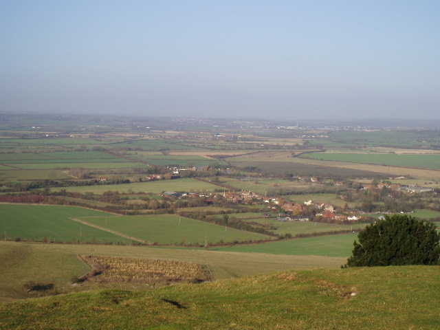
Looking back over Ivinghoe Aston towards Leighton Buzzard, from the summit of Ivinghoe Beacon 19/12/05
On top of Ivinghoe Beacon, I found there were a few people flying kites and model planes, and a young couple sat admiring the splendid view out over the Vale of Aylesbury and along the north escarpment of the Chiltern hills. After quickly taking in the view myself, I turned and started to retrace my steps back to Linslade. I stopped to eat my sandwiches on a stile at the edge of the maize field. It had been a sunny day in the morning, but not too hot – in fact, by mid-morning it felt more like autumn than summer. As I had my lunch, I even contemplated putting my fleece on for the first time in months. The walk back to Linslade went smoothly and without any incident – the walk back along the canal was pleasant but still a bit monotonous. I felt surprisingly tired by the time I got back to Linslade and made my way to the car park in Leighton Buzzard.
Total Distance: 16 miles
Post-walk comments
This was an OK walk, but not one I’d particularly want to do again. The Chiltern Link, which I’d walked a few days earlier, was much more interesting as it was far more varied. The stretch of the Two Ridges Link along the Grand Union Canal was all the same sort of thing, and the rest of the route to the base of Ivinghoe Beacon was also very flat. The short but steep climb to the top of the Beacon was a pleasant little challenge, and the views from the Beacon were as stunning as ever, but otherwise I found little to recommend the Two Ridges Walk. However, to be fair, it does do what it was intended to do, linking one end of the Ridgeway to the Greensand Ridge Walk, making it possible to combine a trip along both those trails.