Pete's Walks - The Chiltern Way
About the Chiltern Way
Note: This was my first attempt at a journal, and is very brief with very few photos (all taken at a later date). I have since walked the Chiltern Way a second time, and have produced a much more detailed journal with many more photographs - see 'The Chiltern Way (2)'.
The Chiltern Way is a circular long-distance footpath that traverses the Chiltern Hills in the south of England, from Bedfordshire to Oxfordshire and back. It is approximately 172 miles long, including its northern and southern extensions. The walk was created by The Chiltern Society in 2000, to celebrate the Millennium, with the extensions to it being added in 2003.
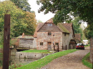
The watermill at Mapledurham, Day 18 (photo taken 26/10/05)
There is an excellent guide book to the Chiltern Way - ‘The Chiltern Way & Chiltern Way Extensions’ by Nick Moon , ISBN 978-0-904148-49-7 (this number is for the 2023 version, which incorporates the many changes to the route since I last walked it in 2007, including temporary changes necessitated by HS2 - the changes to the route are also shown on the Chiltern Society's website). Most of the historical or other factual data that I quote in my journal is taken from this source.
The Chiltern Way does not seem to be shown yet on the OS Explorer maps. However, its route can be followed on the following maps in that series: 171, 172, 181, 182 , 192 (only for a mile-long section northwest of Dunstable) and 193.
Click here to see a very rough map of the Chiltern Way (but only if you have already read my disclaimer and notes regarding maps).
(NOTE: In 2010, a few years after I did this walk, the Chiltern Society celebrated the 10th anniversary of the Chiltern Way by opening a further extension to it, through the part of the Chiltern Hills Area Of Outstanding Natural Beauty that lies in Berkshire. Click here to read about my subsequent walk on the 'Berkshire Loop').