Pete's Walks - The Chiltern Way
About my Walk
I started to walk the Chiltern Way in May 2005, intending to walk two or three parts of the walk each week and so hoping to complete it sometime in August 2005. My plan was to walk the whole of the original route plus both the northern and southern extensions (i.e. I would include the parts of the original route that the extensions omitted), a total of approximately 190 miles. However, as I would be doing the walk by myself, and as there were no feasible ways of utilising any form of public transport, I decided that I would do the whole walk in both directions (a total of about 380 miles). Each day I walked the Chiltern Way, I would park my car near the point on the route that I had last reached, walk about 7.5 miles along the Chiltern Way, and then turn round and retrace my steps back to the car. Although this meant walking twice as far and taking twice as long, I would get to see the views in both directions, it would be twice the challenge and I would have twice as much fun!
There is no official Start or End point on the Chiltern Way. It is a circular route, and it was always intended that people could start at whichever point suited them. Nick Moon’s Guide Book starts and finishes at Hemel Hempstead railway station, but he selected that point only because that is the nearest mainline station to the route. I chose to start and finish at Dunstable Downs, mainly because it is the point on the route closest to where I live. It is also where I first became aware of the Chiltern Way, when I saw one of the special waymark signs for the path.
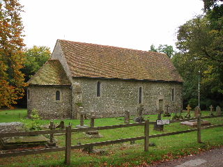
St Botolph's church, Swyncombe, on Day 21 (photo taken 26/10/05)
Please note that this is my first attempt at writing a journal. I didn’t decide to write it until about the 9th or 10th day of the walk, so the first entries are a bit thin but I think it picks up a bit after that.
A note about the photographs: I didn't have a camera with me on this walk, as I didn't decide to create a web site until much later. So I drove round several months afterwards to take some photo's to add to the journal on the site. As in all such cases where the photo's were taken at a later date I have added the date to the captions below the photographs.
Click here to see a very rough map of the Chiltern Way (but only if you have already read my disclaimer and notes regarding maps).
(NOTE: In 2010, a few years after I did this walk, the Chiltern Society celebrated the 10th anniversary of the Chiltern Way by opening a further extension to it, through the part of the Chiltern Hills Area Of Outstanding Natural Beauty that lies in Berkshire. Click here to read about my subsequent walk on the 'Berkshire Loop').