Pete's Walks - The Chiltern Way
If you are considering walking this route yourself, please see my disclaimer. You may also like to see these notes about the maps and GPX files.
Day 14 4/7/05 Burroughs Grove to Colstrope (7.2 miles each way)
Parked in lane in Burroughs Grove.
Another very enjoyable walk, the Chiltern Way just gets better and better!
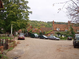
The start of the walk led across a field, through a copse and along a short lane to Marley Bottom. As with all the residential areas the Chiltern Way has passed through so far, this was not as tedious to walk through as I’d expected, the way keeping mainly to secluded footpaths bordered by garden fences. Beyond Marley Bottom, the walk went through a small beech wood and then along a farm access road to cross a surprisingly busy ‘B’ road. It then followed Seymour Court Lane (past the entrance to a house built on the site of a previous house reputed to be the birthplace of Jane Seymour, Henry VIII’s 3rd wife), before a very long descent down a green lane. Another short wooded section led to the attractive hamlet of Bovingdon Green, with a pub by a duck pond and its cottages surrounding the village green. After following a hedge across two or three fields, the route then entered the longest section of beech wood encountered so far, the first part of the Chiltern Way that has really reminded me of the glorious beech woods of Ashridge that I know so well (and which the Chiltern Way will pass through later on). This section ended with a steep but short descent, and then paths across a couple of fields led to another wood, but this time a coniferous one, part of which had recently been felled (judging by the stacks of timber). From here, two more fields were crossed to the hamlet of Rotten Row, and then more fields were crossed before a very long and steep descent, mainly through more woodland, to the very picturesque village of Hambleden. According to the guide book, Hambleden has often been used in TV and films, and it is easy to see why. It is full of quaint old flint-and-brick cottages, with a square (actually more of a triangle) around the old village pump. It’s setting is superb, in a fairly broad, flat-bottomed valley, with steep hills on either side crested by beech woods. From Hambleden, I followed the valley northwards through the hamlet of Pheasant’s Hill (where there was an amusing topiary face cut in the corner of a hedge) to another hamlet, Colstrope, where I turned round.
Hambleden 26/10/05
I had seen some benches by the cricket ground when I first entered Hambleden and had thought that I’d stop for lunch there on the way back. However, as I was walking back from Colstrope to Hambleden it occurred to me that this wasn’t such a good idea, as there was a long and steep ascent out of Hambleden which wouldn’t be much fun on a full stomach. Also, there were some threatening grey clouds approaching (it had been grey skies all morning) and the benches by the cricket ground would have been totally open to the rain. So I decided to have lunch seated on a stile at the top of the hill, just as the path leaves a wood, as it would be more sheltered. This turned out to be one of my better decisions, as the only shower of the day occurred while I was seated on the stile eating my sandwiches! It was quite heavy, but I was sheltered by the trees. The rain seemed to be carrying on when I finished lunch, so I donned my waterproofs before setting off again, but within a few hundred yards the rain had stopped. I kept my overtrousers on, though, for the next couple of miles where I had to walk through several fields, as I didn’t want to get my trousers soaked by the damp crops (because this could cause my socks to get wet and thus cause blisters). Again, this was another day when I was very fortunate with the weather.
As I was returning towards Hambleden I saw another bird of prey, but was too far from it to determine whether it was a buzzard or a red kite (I must remember to take my binoculars with me!). I also saw a Jay and a Green Woodpecker today, birds I see a lot on the walk but haven’t bothered to mention before. I also got a fleeting glance of a Muntjac deer (just as I was getting back to Marley Bottom), the first deer of any type I’ve seen so far on this walk.
Total distance: 101.6 miles (each way). Over two hundred miles walked, and over the half way mark! I have just calculated that the whole route will be 192.5 miles each way, a grand total of 385 miles. This is made up of the route including both northern and southern extensions, plus the bits on the original route that the extensions omit, plus a half-mile ‘shortcut’ that cuts off the ‘Ewelme loop’ in the south-western extremity of the original route.