Pete's Walks - The Chiltern Way
If you are considering walking this route yourself, please see my disclaimer. You may also like to see these notes about the maps and GPX files.
Day 15 6/7/05 Colstrope to Maidensgrove Common (7.7 miles each way)
Parked on main road in Skirmett.
What a superb day! Having read the guide book, I’d been particularly looking forward to this section of the Chiltern Way and it more than lived up to my expectations. The scenery was lovely, certainly the most picturesque part of the walk so far, and the various villages and hamlets that I passed through all had their different points of interest. But the most striking feature of today’s walk were the Red Kites! I’d seen a couple back in Penn Bottom a few days ago, only the fourth sighting I’d ever had (the first two were in mid-Wales, back in the days not so long ago when that was the only place in Britain you could see them, and the third was at Minsmere in Suffolk in early January last year). I knew they were doing well in the western half of the Chilterns (we don’t get them at all in the eastern half were I live), but I had no idea that they were now so common! Today, I doubt that I ever walked for more than 20 minutes without seeing or hearing them.
The day started off with a much nicer car journey than I’ve had for the last few days. Now that I’ve got to the west of High Wycombe on the Chiltern Way, I can take a totally different route just to the north of the Chilterns, instead of having to drive through the centre of the Chilterns. So instead of being held up in the traffic of major towns such as Chesham, Amersham and Wycombe itself, I just pass through smaller places such as Tring, Wendover and Princes Risborough. Without the traffic jams, I got home in 55 minutes, 20 minutes quicker than after my last walk.
I started the walk by walking just over a mile from Skirmett back to Colstrope, a very pleasant walk through grass meadows along the same scenic valley that the last walk had reached. A short section went through a green lane, where there were so many large tree roots across the path, it was almost like walking on the sleepers of a railway line. After turning round at Colstrope, as I was getting back to Skirmett I saw a large bird on the skyline to my right, but couldn’t tell for sure that it was a Red Kite. But almost immediately I saw one over to my left, that was clearly recognisable. Then I saw another as I was crossing a field behind Skirmett - and it was quickly joined by another, then another … I was amazed to count seven of them, but then realised that one of them was actually a Buzzard (rounded, fan-shaped tail, whereas the Kites have a slightly forked tail). I crossed the field and then had to turn along the hedge at the far end. As I walked along that side of the field, three of the Kites took off from the ground, but instead of flying away from me, they flew towards me and over my head, giving me fantastic views of them (no need for my binoculars!). It was almost as if they were showing off - they’re gorgeous birds, and they know it!
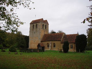
Fingest church 26/10/05
The path then lead up a steep green lane into a wood and continued rising - I could still hear the sound of the Kites as I walked through the wood. Then the path crossed a grassy meadow (another Kite in view) to a copse. On the other side, I met a group of about 8-10 ramblers (unusually unfriendly, only one of them said ‘Hello’ when I tried to greet them as I went by). There were fantastic views down to Fingest, at a junction of valleys. I took the long descent down to Fingest (Kite flying in the valley), where the church had a very impressive Norman tower. A short walk contouring round the side of a hill then lead to a meadow that had obviously been ‘set aside’ for nature as it was full of poppies, buttercups and numerous other flowers that I’m too ignorant to recognise (another Kite). This then lead into the charming flint-and-brick village of Turville, the setting for the TV series ‘The Vicar of Dibley’ apparently. On a hill above it was Cobstone Mill, the windmill used in the film ‘Chitty Chitty Bang Bang’ (and in other films and TV programmes). The mill had first been visible as I’d walked up the valley towards Skirmett. The church in Turville had an intriguing story - in 1990 an ancient coffin was found hidden under the floor, containing not only the skeleton of a 13th Century priest, but also that of a 17th century woman with a bullet hole in her skull! (N.B. As usual, these snippets of information have been gleaned from the guide book).
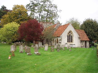
Turville church 26/10/05
From Turville, the way led across some fields (more Kites) to a small wood (where I saw my first Fallow Deer of the walk so far) and then across a large field with a ‘Beware of the Bull’ sign. I didn’t see the bull amongst the numerous black cows then, but did see him on the way back (just after I’d put my bright red waterproof jacket on!). A short farm road led on to the hamlet of Southend (another Kite). From there, a nice track descended through woodland (sound of Kites) to the park of Stonor House, through which the footpath continued to descend (more Kites) for almost a mile before reaching a road on the edge of the village of Stonor. Stonor House looked impressive - the guide book says that both it and its chapel were built in 1280, although altered many times since, and have remained in the possession of the Stonor family all that time. The house did look mainly Georgian to me, but the chapel still looked as if it was mediaeval.
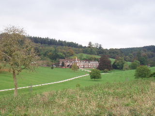
Stonor House 26/10/05
From Stonor, the way led uphill across fields (4 kites) where I saw a group of seven Fallow Deer (I won’t count the seventeen I saw on the way back as they were in the Deer Park around Stonor House). It then passed through a small beech wood and across a very stony field to the remote hamlet of Maidensgrove. A short walk along a lane and along a track onto Russell’s Water Common (a very large area of grassland, almost surrounded by woods) reached the point were I turned round. I stopped soon after for lunch on a stile where the stony field met the beech wood - needless to say, an obliging Red Kite gave a demonstration of aerobatics while I ate. There were a few spots of rain during my lunch so I put my waterproof jacket on, but I took it off before I started the mile and a half of gradual ascent through Stonor park (Kites) and on back to Southend. At Southend, there were a few spots of rain (hence I had my bright red jacket on when I met the bull) but I only needed it for 10 minutes or so. By the time I got back to Skirmett it was a nice sunny afternoon, but not too warm as there had been a fairly strong wind most of the day. Three or four kites were there in the same field by Skirmett as before, to welcome me back. One of them flew over the field, and actually seemed to follow me down the path for a short way, soaring 30 or 40 feet above my head. They don’t seem at all bothered by humans, several came quite close to me and they seemed as common in and around the villages as they did in the more remote parts of the countryside.
Unsurprisingly, I saw two more Red Kites on my drive home. The first was just as I went through a bridge under the M40 (I’ve heard many times that they can be seen from that motorway), and the second was between West Wycombe and Princes Risborough - perhaps they are spreading eastwards, and we may soon have these delightful birds in our area. Also on the way home, a DJ on Classic FM played Elgar’s Pomp and Circumstance No 1 (a.k.a Land of Hope and Glory) to celebrate London winning the bid for the 2012 Olympics! It felt very appropriate (and I’m not someone who’s usually in the least bit patriotic).
Total distance: 109.3 miles (each way)