Pete's Walks - The Chiltern Way
If you are considering walking this route yourself, please see my disclaimer. You may also like to see these notes about the maps and GPX files.
Day 16 7/7/05 Maidensgrove Common to Crocker End Green (7.2 miles each way)
Parked on verge at Maidensgrove Common.
As today’s walk was not my usual ‘walk 7.5 miles, turn round and come back’ routine, I’d better spend some time explaining the route I followed today. Firstly, let me explain about the ‘Ewelme loop’ (it took me several readings of different sections of the guide book before I got my head round this!). The Ewelme loop is a section in the far south-western corner of the original route of the Chiltern Way, where about 10 miles of the way turns back on itself to finish within ½ a mile of its starting point. The guide book mentions a ‘short-cut’ that crosses this gap, thus giving the possibility to shorten the whole Chiltern Way by about 10 miles, or else of creating a 10 mile circular walk. To complicate matters, the southern extension branches off the original route about ½ mile before the ‘short-cut’ begins, and rejoins the original route about halfway round the Ewelme loop. I want to do all of the original route, plus the extensions, and also the ‘short-cut’ (just for completeness - not sure how ‘official’ it is). So, from today’s starting point at Maidensgrove Common, I walked ½ mile to where the southern extension splits off (left) from the original route, stayed on the original route for another ½ mile to where the short-cut splits off (right) from the original route, walked the ½ mile short cut each way, continued on the original way about 5 miles to where the southern extension rejoins it (from the left), turned round and retraced my steps all the way to where the southern extension began, walked about 1 mile on the southern extension and the same back again (this was just to bring today's mileage up to my normal 14 or 15, and to finish at a convenient place for me to park next time), and then the last ½ mile back to my car. The point of this convoluted walk was that it means I now only have to complete the southern extension and the rest of the original route, with no more ‘side-trips’ required.
I was in two minds about doing the walk today as it was raining heavily when I set off from home this morning, but the forecast had said it would be drier in the west. As it turned out I was very fortunate with the weather, the rain stopped as I was putting on my waterproofs in the car when I arrived at Maidensgrove Common. There were two or three showers in the afternoon and it was generally grey and gloomy, but I never had any heavy rain and the last 10 minutes of the day were in glorious sunshine.
The first ½ mile was downhill across two fields and through two small woods, quite steeply downhill in places. I was a little confused at the point where the southern extension split from the original route (the sign post had been vandalised), but eventually worked out which way the original route went. I followed it along a pleasant green lane in a valley bottom, with a stray sheep and its two lambs running along in front of me. After ½ mile, I ignored where the original route turned off, and continued along the green lane to do the ½ mile shortcut. I then turned round and returned to the original route, which lead uphill across a field with cows in, and then across several more grass fields to a short green lane into the hamlet of Park Corner. Apart from the hamlet of Crocker End Green near the end of the walk, this was the only ‘civilisation’ I came across all day apart from one or two isolated farms. From Park Corner, I took a field path into a wood and along a green lane to a second wood. The path then went for about two miles down to and along a valley bottom, first through woodland then in a green lane with thick hedges either side. This was probably the longest stretch of continuous path with no turns in it that I had come across so far. At one point it crossed the Ridgeway, another walk I’d like to do. Eventually the path emerged onto a farm track and then on to another green lane called ‘Old London Road’. I followed this for about ½ mile, with views out across Oxfordshire - I couldn’t see the ‘dreaming spires’ of Oxford in the gloomy conditions but I could see Didcot power station! The last ½ mile or so to where the southern extension rejoined the original route was across more fields, where skylarks were singing. The paths rejoined at Potter‘s Lane (near Ewelme), by a large barn which my nostrils were telling me was part of a pig farm. I turned round and retraced my steps for the 5 or so miles back to where the southern extension branched off, stopping to eat my lunch on a fallen tree trunk alongside the long straight green lane I mentioned earlier (near the Ridgeway crossing). There were two or three showers in the afternoon, so I was frequently putting on or taking off waterproofs. I did 0.9 miles each way at the start of the southern extension, to the hamlet of Crocker End Green, through meadows and a couple of field with cows. Finally, the last ½ mile back to the car was mainly uphill, and quite steep in places - through one short wooded section wooden steps had been created for the path.
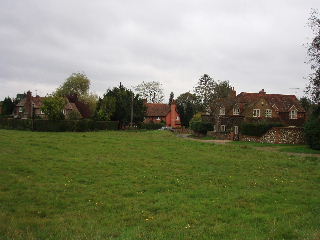
Crocker End Green 26/10/05
Yes, I did see more Red Kites today, but I won’t bore you with the details. I also went past a field of Alpacas (like Llamas, but woollier - a bit like sheep with stretched legs and neck!).
Of course, everything today was overshadowed by the terrible atrocities in London. What a contrast to the joyous celebrations of yesterday.
Total distance: 116.5 miles (each way)
(N.B. Gap of about 12 days, due to very hot weather (30C), injury to knee, and week-end away in Ipswich)