Pete's Walks - The Chiltern Way
If you are considering walking this route yourself, please see my disclaimer. You may also like to see these notes about the maps and GPX files.
Day 17 19/7/05 Crocker End Green to Sonning Common (8.2 miles each way)
Parked on edge of green at Crocker End Green.
This was a very warm day, with the temperatures probably reaching 25C in the afternoon, but there was generally a fairly stiff breeze to cool things down.
The walk, the first full day on the southern extension, started from the hamlet of Crocker End Green through a very large field of grass with trees dotted around (typical of a ‘park’ around a large house - this was the parkland of Soundess House, reputedly the home of Nell Gwynne). It then led through mixed woodland (including a plantation of yew trees) and then downhill alongside a hedge to a lane at Bix Bottom (there are lots of ‘bottoms’ in the Chilterns, it just means a valley, usually a dry one i.e. one without a stream or river running through it). There was a village here in Norman and later times, but now there is just a farm and the remains of a Norman church. A short walk along a lane, then through a farm yard and across a field, led to more woodland, mainly beech. This was followed by the crossing of a ploughed field, where the path was rather indistinct, to the village of Bix, on a busy main road.
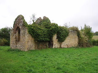
Ruined church at Bix Bottom 26/10/05
From Bix, the path led across several cow pastures, passing close to a farm, and then entered another beech wood (intriguingly named ‘Famous copse’). This was followed by three more fields and another short section of wood, and then across two more fields to the entrance to Greys Court. This is a National Trust property, originally a mediaeval castle (some fortifications from 1348 survive) but most of it now dating to when it was rebuilt after the civil war. It looked interesting, I’d like to go back and have a look round it sometime. From Greys Court, the path led through another short woodland section to the cricket ground at Greys Green.
The section of the Chiltern Way after Greys Green was very pleasant, as it followed a very wide bridle path for a couple of miles, initially alongside a golf course, then alongside a wood and finally between fields until it became a paved lane just before reaching the hamlet of Harpsden Bottom. The path then went across a very large field (presumably ‘set aside’, as it was all long grass and wild flowers) that is part of Crowsley Park, and past the Georgian house there. A short section along a lane through the hamlet of Crowsley followed, and then more fields were crossed to emerge on a road by the ‘Bird in Hand’ pub just south of Sonning Common.
At 8.2 miles, this was one of the longer walks I did on the Chiltern Way, and I was quite pleased to reach Sonning Common in 2½ hours, enabling me to walk a couple of miles of the return journey before stopping for lunch. In the afternoon, I had time to take a quick look round the ruined church at Bix Bottom.
Total Distance: 124.7 miles (each way)