Pete's Walks - The Chiltern Way
If you are considering walking this route yourself, please see my disclaimer. You may also like to see these notes about the maps and GPX files.
Day 2 17/5/05 Chalton to Barton-le-Clay (7.3 miles each way)
Parked in side street near village hall in Chalton.
There was a two-week interval between my first and second walks, because I had a heavy cold or virus which took time to shake off. By the time I did this walk, I’d decided to do both the Northern extension, as well as the part of the original route that the extension omits. At Sharpenhoe Clappers, I branched off onto the extension.
This was a much nicer walk than the previous one, possibly helped by sunnier weather. After a messy first mile (over the M1 and a railway line, and then through a couple of old quarries), much of the walk from Upper Sundon to Sharpenhoe Clappers was along the top of the northern slope of the Chilterns, giving extensive views over much of Bedfordshire. This was a very pleasant section of the walk that I’d like to do again. About a mile or so before I reached Sharpenhoe Clappers I saw a Buzzard (a sighting confirmed by some bird watchers I met when I reached the Clappers).
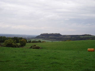
Sharpenhoe Clappers from Sundon Country Park 22/10/05
Having descended the steep slope from Sharpenhoe Clappers into Sharpenhoe, and then followed footpaths through fields the mile or two to Barton-le-Clay and its church, I turned round and stopped for lunch back at the Clappers, after a stiff but brief climb. This was about 1.30, half an hour later than I usually stop, but it meant the afternoon’s walking went very quickly and I was surprised how quickly I got back to the car.
Total distance: 14.7 miles each way