Pete's Walks - The Chiltern Way
If you are considering walking this route yourself, please see my disclaimer. You may also like to see these notes about the maps and GPX files.
Day 3 19/5/05 Barton-le-Clay to Wellbury (7.3 miles each way)
Parked by entrance to recreation ground in Barton-le-Clay.
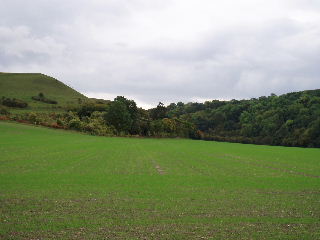
Barton hills, from the edge of Barton-le-Clay 22/10/05
This was a thoroughly enjoyable walk, despite less than perfect weather conditions. It was drizzling as I left the car, but as I ascended the Barton Hills after about half a mile, it changed to very heavy rain. I struggled to get my waterproofs on as it also became very windy. Fortunately the rain lasted only about 15 minutes, and the rest of the day was dry but totally grey and overcast. The walk followed the top of a steep-sided combe in the Barton Hills, which was a dramatic start and finish to the day. It then followed broad tracks for several miles, part of the journey coinciding with the Icknield Way. I crossed Telegraph Hill (the highest point in North Herts) and went past Lilley Hoo where the Prince Regent raced his horses. The long descent down to Pegsdon was a very pleasant part of the walk (coming back up it in the afternoon wasn’t quite so pleasant!). Originally I’d intended turning back when I reached the B655 near High Down House, but walked on until I reached a bridleway just beyond Park View Stables in Wellbury. (The bridleway met the B655 near a small car park I‘d be using for my next walk, and thus would save me a much longer and rather dangerous walk along the B655 from the car park to where the Chiltern Way crosses it).

The deep combe of Barn Hole with Pegsdon hill on the right 22/10/05
Just after I turned round, I met another walker, a lady who obviously lived locally. She said that this part of North Herts was a ‘hidden jewel’, and I had to agree with her.
Total distance: 22 miles each way