Pete's Walks - The Chiltern Way
If you are considering walking this route yourself, please see my disclaimer. You may also like to see these notes about the maps and GPX files.
Day 21 26/07/05 Ewelme (Potter’s Lane) to Oxfordshire Way (College Wood) (8.3 miles each way)
Parked at recreation ground in Ewelme.
This was a nicer day than yesterday, weather-wise, as although the skies were very cloudy, some patches of blue could be seen and it was much brighter, meaning the views were that much better. It was also very much warmer. I enjoyed the walk much more too, probably because the Chiltern Way left the ‘foothills’ and returned to the Chiltern Hills proper.
From Ewelme, where I parked, I had first to go about a mile back to Potter’s Lane, where the southern extension rejoins the original route. This was across fields, mostly on a bridleway, passing alongside a small quarry. Again, I could smell the pigs - typical, this is the only point on the route that I will visit three times, and it’s the only place I remember that smells of pigs! Still, I shouldn’t complain, I don’t smell too good myself at the end of one of these 15 mile walks. On the way back to Ewelme, I met across a couple of horse riders, the first ones I’d met since near Marlow Bottom. The view of Ewelme was very nice as I got near the village.
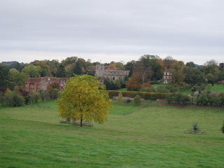
Ewelme 26/10/05
From Ewelme, the Chiltern Way followed a clear track through corn fields, descending to a lane, then round two sides of a field to a car park at the foot of Swyncombe Down. A steepish ascent through wood and scrubland followed (though not as long or arduous as I’d expected), emerging onto a more open area at the top of the down.
The path across the top of Swyncombe Down followed the line of an ancient earthwork called the ‘Danish Intrenchment’, thought to have possibly been made when the Danes tried to occupy southern England in the 870’s (but were repelled by King Alfred). It then followed the hedge of a field, descending then re-ascending quite steeply to reach Swyncombe. I met a party of four girls here, who were walking the Ridgeway path (which coincided here with the Chiltern Way for a few hundred yards). They were doing the whole 61 miles in just three days, but three of them already had blisters after walking 22 miles the first day.
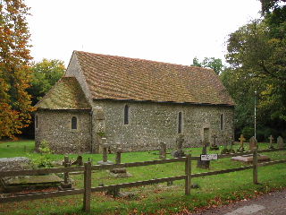
St Botolph's church, Swyncombe 26/10/05
St Botolph’s church at Swyncombe dates from the 11th century. I walked through the churchyard, but didn’t have time to go inside the church - not sure if its open anyway, there were warnings of CCTV cameras in operation. From Swyncombe, the path led through a large park attached to Swyncombe House, then through woods (were I saw a Muntjac deer on my return trip) and then a short stretch along a road into Cookley Green. Here I crossed the village green and took a well-used bridleway along a green lane to the village of Russell’s Water - part way along I reached the end of the ‘Short-cut’ that I walked on day 16, and so completed the ‘Ewelme loop’ mentioned in the guide book.
Russell’s Water was an attractive village with its duck pond. From there, I followed the edge of Russell’s Water Common, a large expanse of grassland, and then descended through a wood to a road in Pishill Bottom.
Another embarrassing revelation! No, I didn’t get lost again - I just forgot where I was supposed to stop and turn round today! This walk was meant to be slightly shorter than usual, 7.0 miles to Pishill Bottom and then back again. Instead, I somehow thought that I needed to do the next 1.3 mile section through woodland before turning round. In fact, I only realised my mistake when I reached the end of the woods and, thinking I’d only done 7.0 miles, was seriously contemplating walking a bit further to shorten the next day’s walk! So today’s walk ended up as about 8.3 miles each way, one of the longest on the entire route. Still, the walk through the woods was very pleasant (one of the longest woodland stretches so far) and it means I can shorten the next couple of days walking (I was looking at about 7.8 miles for each of the next three days).
For the second day in a row I ate my lunch seated on a stile, this time at the end of the long woodland section. The return journey went very smoothly, and the skies brightened up a bit. The views from around Swyncombe Down were pretty good - as well as Didcot Power Station and Wittenham Clumps, at one point I could see the research laboratories at Culham. When I was a student, some of my friends worked there while I was working at the nearby research centre at Harwell.
Total Distance: 155.3 miles (each way) - I passed the 300 mile mark today!