Pete's Walks - The Chiltern Way
If you are considering walking this route yourself, please see my disclaimer. You may also like to see these notes about the maps and GPX files.
Day 22 29/07/05 Oxfordshire Way (College Wood) to Bledlow Ridge (7.2 miles each way)
Parked in Ibstone.
This was a very pleasant and scenic walk, with some very good views down long valleys. But I found it surprisingly strenuous, it was certainly the hilliest section of the Chiltern Way so far - I think I must have ascended and descended about 2000 feet during the day, although no individual ascent or descent was more than about 300 feet. Still, I’m not complaining, these are the Chiltern Hills after all! It was a rather cloudy day, with a few bits of blue sky visible, but a very pleasant temperature, neither too hot nor too cold.
At the start of the day, I had to walk the 2.7 miles from Ibstone back to College Wood. Ibstone was the nearest possible parking place to where I’d last finished, and according to the guide book parking could be a problem for the next two or three walks. This section was very pleasant. The first few hundred yards from Ibstone, through a wood with the sound of Red Kites overhead, was slightly overgrown with bracken, although it was clear where the footpath went. Having passed two small ponds, the Chiltern Way entered the Wormsley Estate (owned until recently by the late Sir Paul Getty - it has its own cricket ground). The route then followed a sunken way downhill, before a much steeper downhill path led out of the wood to a good viewpoint for the Wormsley valley. Three fields were then crossed on good paths across the valley, before a steep ascent through more woodland led out of the Wormsley Estate and on to the hamlet of Northend (like Southend that I passed through on Day 15, it takes its name from its position within the parish of Turville, the ‘Vicar of Dibley’ village). The Chiltern Way then descended slightly to the bottom of a small valley, and followed the valley bottom for about a third of a mile, reaching a small wood. A very short but quite steep climb out of the wood led to a final meadow, which led to the lane where I’d finished my previous walk.
As I returned to Ibstone, I saw some Fallow Deer on the edge of a field in the Wormsley valley. At first, from a distance I thought they looked a bit small for Fallow Deer, but I decided that that was what they were because one was a much darker brown than the others. Fallow Deer vary enormously in colouring, often fairly pale brown, sometimes with white spots, but sometimes a very dark brown and sometimes almost white. I once read that the white ones are called ‘Poacher’s deer’, because poachers never killed them as they were so much easier to spot and so gave away the whereabouts of the better camouflaged deer. Anyway, as I got nearer to them I could see that they were indeed Fallow Deer, and that one of them was a fawn, the first I’ve seen for several years - probably when I see the deer in woodland, the fawns are hidden from view by the undergrowth.
From Ibstone, the Chiltern Way then continued through more beech wood, steeply downhill, then back uphill following the outside edge of the wood. It then crossed two fields (one with sheep, one with some friendly horses) to reach a farm. On the other side of the farm, it crossed two more grassy fields to reach a copse in a valley bottom, where it joined a farm track that led on to another farm. From here, the Chiltern Way took an underpass below the M40 (there were four Red Kites soaring above it) to reach the large village of Stokenchurch. (The only member of the aristocracy that I have ever met lived in Stokenchurch - he was working as a computer programmer in Greenford in Middlesex, which is also on the A40).
On the other side of Stokenchurch, the Chiltern Way crossed another grassy field, then a corn field, before following a flinty track for a few hundred yards. It then crossed to the other side of a hedge, and followed the hedge through two more fields before crossing another track and then crossing diagonally downhill across a corn field to reach a further track (known as Collier’s Way, as it was once used by Welsh colliers taking coal to London). This track was left after a short while, as the Chiltern Way cut across the corner of another corn field and passed through a horse paddock to reach a farmyard. It then crossed an adjacent lane, and went diagonally uphill across another corn field. A short path then led to another farm, and then followed a left-hand hedge downhill again.
Here I met another walker (a man in his early sixties, I’d guess) who asked if I was doing the Chiltern Way. I replied in the affirmative, and said that if he was doing it too then he was the first other Chiltern Way walker that I’d met. He seemed a bit confused by my answer - it was only afterwards that I realised why. He (and his wife who soon joined us) were doing a walk that they’d photo-copied from a book - the photo-copy wasn’t too clear, the map part of it was near useless. Not surprisingly they had got lost. I told them the name of the farm I’d just passed, which didn’t help them, and offered to get my map out of my rucksack to show them where they were, but they said there was no need (it occurred to me afterwards that perhaps they couldn’t read maps, as they’d been following the written instructions on their photo-copy). Their walk was called a ‘A Chiltern Walk ….’ (I forget the rest). Again, it was only afterwards that I realised that they’d been following Chiltern Way markers, thinking it was the same thing as their walk! The woman pointed over to a hill and said that that was Bledlow Ridge where they had to get back to. Not having been there yet (it was the destination for my walk today), I assumed she knew what she was talking about. It was only when I got to Bledlow Ridge that I realised she was wrong, and had pointed to a hill on the other side of a very wide and deep valley, a good mile or two from where she actually wanted to go. With hindsight, I wished I’d told them that I was going to Bledlow Ridge and that they could follow me there. I didn’t see them again on my return trip - I just hope they managed to get back to their car at Bledlow Ridge eventually.
I was rather disappointed that the two lost walkers weren’t doing the Chiltern Way, as I have yet to meet anyone else walking it. I’ve been enjoying it so much, it would be a shame if no one else was making use of it.
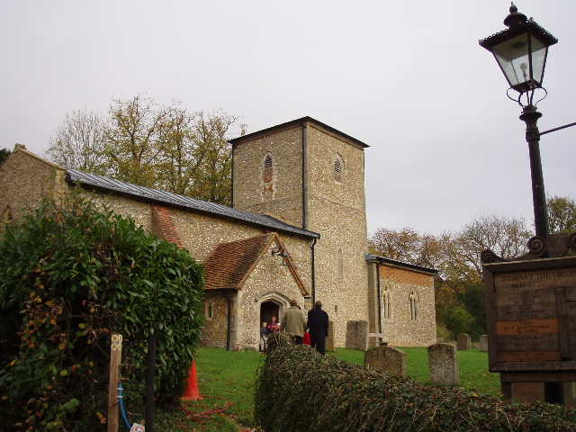
Radnage Church 5/11/05
Having parted from the two lost walkers, I continued alongside the hedge down to a lane into part of Radnage (a village consisting of several small hamlets) and crossed a field to reach the village church (13th Century with an unusual central tower). After walking through the churchyard and over both a stone and a wooden stile, I crossed two grassy fields (unusually, the second one had precisely two cows in it) before the path led steeply uphill again through a third field. Still steeply uphill, a strange field of scrubland followed, before a wood was entered where the path levelled off, and a fenced path alongside a hedge led to the road at Bledlow Ridge.
I turned round here, and eat a late lunch seated on a stile in the wood I’d just passed through. Because of the 2.7 miles back to College Wood at the start of the day, I’d planned on having lunch before reaching my ‘turn-round point’ today, which would have been the first time on this journey. However I didn’t really find a suitable spot (mainly because I didn’t want to stop somewhere where I’d have a steep ascent straight after lunch), so I ended up having lunch about 1.45pm. I normally have lunch about 1pm, although as I’ve been starting my walks a bit later recently, due to the time spent driving to the start of the walks, its been about 1.15 or even 1.30 on some days.
The return trip to Ibstone went very smoothly, and as always it was a pleasure to see and hear some Red Kites (one over the very centre of Stokenchurch, another over the M40, amongst many others). The last steep climb through the wood to reach Ibstone was a bit of a struggle, the guide book should have warned me about this section! I checked the map when I got home, to work out how much up and down I’d done - my legs were telling me that my estimate of about 2000 feet wasn’t far out! If I struggle that much on hills of just 300 feet, goodness knows what I’ll be like when I go walking with some friends in the Lake District in a couple of months time!
Total distance: 162.5 miles (each way)