Pete's Walks - The Chiltern Way
If you are considering walking this route yourself, please see my disclaimer. You may also like to see these notes about the maps and GPX files.
Day 23 2/8/05 Bledlow Ridge to Redland End (7.7 miles each way)
Parked in side street at Bledlow Ridge.
I hadn’t been particularly looking forward to this section, one reason being that the guide book made it sound very ‘bitty’ with lots of short stretches between hamlets and villages meaning I would need to concentrate a lot on navigation. The main reason, though, was because a large part of the route formed an upside-down ‘U’ shape, meaning that at the end of the walk I wasn’t really that far from where I’d started. If the diversion was because of a particular natural feature or fine viewpoint, I could understand it, but as it was only to reach the village of Bledlow (interesting, but not that interesting) it seemed a bit pointless.
I shouldn’t have worried - this was another glorious walk on a lovely warm summer’s day. From Bledlow Ridge, the Chiltern Way took field paths to the hamlet of Rout’s Green, the impressive views to the right over Lodge Hill and the Saunderton valley being marred slightly by the morning haze (better views when I returned in the afternoon!). A sunken lane then led gradually downhill through a wood. A green lane then led on past two old farms, before a farm drive was followed to a lane. Crossing this, the way then lead across a grassy field to then join the Ridgeway for a few hundred yards, before leaving it to descend diagonally across a ‘set aside’ field. It then went steeply uphill briefly through a small thicket, before following the left-hand side of a hedge through two large corn fields to reach Bledlow
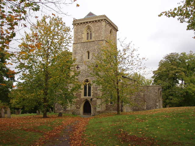
Bledlow church 5/11/05
As the guide book said, Bledlow was quite interesting, with its church, manor house, houses with herring-bone brickwork, and an old children’s home. From there, the path led diagonally across another large field to reach a green lane (possibly Saxon in origin) which was quickly left to cross another field to a farm drive, followed by a lane leading to Saunderton. Here I took a path through the churchyard and then through a rather marshy section which was the site of a castle, before following another hedge and crossing a railway line. I then followed the drive of an old rectory before crossing two more fields, and then walking over the top of an entrance to a tunnel on a second railway line. The path then crossed more corn fields , crossed a busy main road, and after one more field reached a farm road. This led uphill, passing a farm before a short but steep path led to a road at Loosley Row, from whence another short road led to the adjoining Lacey Green.
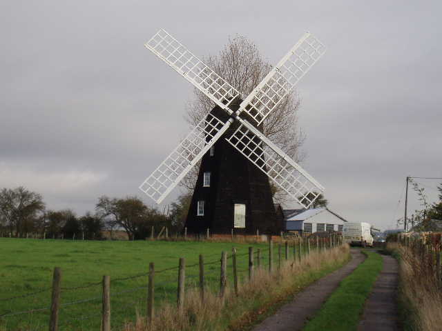
Lacey Green windmill 5/11/05
Here I passed close to a windmill, the oldest surviving smock mill in the country. (built in 1650 in Chesham, rebuilt on it present site in 1821 and restored by members of the Chiltern Society in the 1970’s and 1980’s). More field paths were followed by a horse paddock and then a fenced track between further paddocks. A large field of grass was then crossed (where I saw a Red Kite take off from the ground) before a short path across a corner of a corn field led to a belt of trees - here I came across Grim’s Ditch, an ancient earthwork (thought to predate the Saxons, as Grim is an alternative name for their god Wotan, and it is thought unlikely they would name something they built themselves after one of their gods). This led on to Lily Bottom, a tiny hamlet close to the ‘Pink and Lily’ pub where the poet Rupert Brooke drank before the First World War (I seem to be quoting a lot of stuff from the guide book in this section!). The Chiltern Way then proceeded through woodland to a lane junction, where a short lane led on to the hamlet of Redland End, my ‘turn-around point’ for the day.
The walk back in the afternoon was very pleasant. I had my lunch near the railway tunnel entrance, sitting down by the path watching some butterflies as I ate. It was quite warm in the afternoon, but a strong breeze cooled me down. As I got back to Bledlow Ridge, I could enjoy the expansive views over the wide Saunderton valley and could see the windmill at Lacey Green which had been obscured in the morning haze. I could also see Whiteleaf Cross, a cross of an unknown date carved into a chalk hillside.
Total distance: 170.2 miles (each way)