Pete's Walks - The Chiltern Way
If you are considering walking this route yourself, please see my disclaimer. You may also like to see these notes about the maps and GPX files.
Day 24 3/8/05 Redland End to St Leonards (7.3 miles each way)
Parked on verge at Redland End.
This was another superb walk. The weather was very good again, a bit cooler than yesterday but warm enough, some clouds but generally bright and sunny. The countryside was just how I’d hoped and expected the Chilterns would be like. Rolling hills and long valleys, interspersed with woods, dotted with small hamlets of flint-and-brick cottages.
From the tiny hamlet of Redland End, the Chiltern Way led through a beech wood, initially following Grim’s Ditch again, before crossing a large parkland field belonging to Hampden House. Unusually, the park was all corn or similar cereal, usually parkland around a big house is grass with cows and/or sheep grazing on it (it was still recognisably parkland because it had the odd tree or small copse here and there). The path then crossed in front of Hampden House (home of John Hampden, a leading Parliamentarian at the time of the Civil War). I noticed there was a ha-ha in front of the house - this is a hedge or, as in this case, a fence, at the bottom of a large ditch, the purpose being that it acts as a boundary without spoiling the view from the house (no idea why it has such a daft name!).
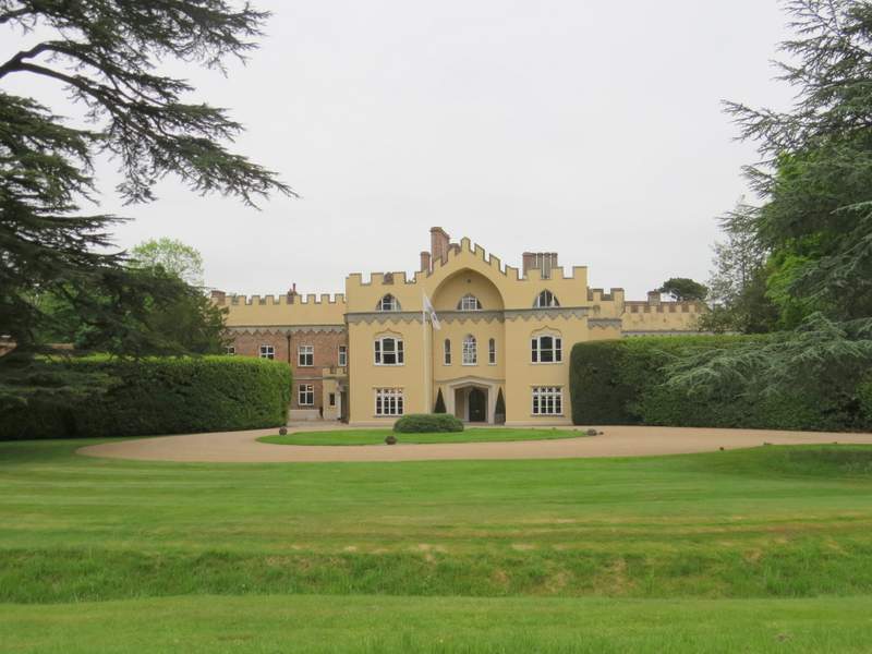
Hampden House (with a HaHa in the foreground)
The path then led through Lady Hampden’s wood, before gently descending diagonally through a large corn field towards the road in the long broad valley of Hampden Bottom. I saw a Red Kite over the wood as I was descending the path, almost certainly the last one I will see on this walk - I didn’t see or hear anymore today, so I assume I’ve now reached the eastern edge of their range. I shall miss seeing and hearing them, they have really added to my enjoyment of this walk I just hope that they will soon extend their range another 20 or so miles eastwards to the part of the Chilterns where I live.
On the other side of the road in Hampden Bottom, the path led uphill through a long belt of trees - the path here was rather overgrown, very unusual compared to most of the rest of the Chiltern Way. Eventually the trees were left, and a rising path led across a meadow and then steeply through another belt of trees. A short permissive path then led round the corner of a field and into another wood, where the path led onto a green lane that eventually became an unmade road leading into the remote hamlet of Little Hampden. From here, another path led downhill through a wood and then along the edge of a field. At the valley bottom, the path switched to the other side of the hedge and followed it uphill to reach another short section of wood. On the other side of this, a grassy field was crossed diagonally and then two stiles led on to a track that took me to another hamlet, Cobblers Hill.
There then followed quite a long section through a large wood, quite complicated as the path branched and forked at several places. I checked that these turn-offs were marked with Chiltern Way signs, so that I would be confident of finding my way back (I didn’t want to get lost again!). As usual, the route was well marked, either with the small round ‘Chiltern Way’ signs or else with arrows and/or CW painted in white on a tree. Eventually the path led downhill along a sunken lane, emerging from the wood onto a wide track that led over a railway line. Just past that, the Chiltern Way left the track and followed a path across another small area of parkland (belonging to the adjacent Mayortorne Manor) and then across some paddocks, to reach a busy main road in Wendover Dean.
After crossing the road, I followed a short lane to a T-junction and crossed a large grassy field. Two stiles took me across a lane to a farm, and then I crossed two more grassy fields, steadily rising up the hillside. The path then went half-left across a corn field, to reach a lane by one of two isolated cottages - the view back across the valley was very attractive. Two more fields were then crossed before a short track led to the car park of the pub at Lee Gate. Another couple of fields were crossed to reach another short track that led into Kingswood. From here, there were some more horse paddocks to cross, before the path went diagonally through a thin piece of woodland and then across a couple of corn fields to reach Arrewig lane (its name come from the Saxon for ‘way to the arable fields’, apparently).
After about 70 yards on this lane, the path crossed a field that was obviously ‘set aside’ (or else there’d been a truly disastrous crop failure!) and through yet another wood. After another small field was crossed, a bridleway was followed, passing Dundridge Manor (which had a drawbridge over its moat), before lanes were followed the final few hundred yards into St Leonards.
I struggled to find somewhere suitable to stop for lunch on my walk back, eventually sitting on a tree root way back past Wendover Dean. My late lunch (about 1.25) and early start (9.40) meant I had less than 1½ hours walking after lunch. The whole day’s walk was thoroughly enjoyable, and certainly one of the best days that I have had on the Chiltern Way.
Total Distance: 177.5 miles (each way)