Pete's Walks - The Chiltern Way
If you are considering walking this route yourself, please see my disclaimer. You may also like to see these notes about the maps and GPX files.
Day 25 8/8/05 St Leonards to Berkhamsted Common (7.0 miles each way)
Parked at Buckland Common.
Another great day walking the Chiltern Way! This was a very pleasurable walk, on a lovely warm sunny day. More typical Chiltern scenery of rolling hills, wide valleys and beech woods. The walk ended in Berkhamsted Common, an area I know very well as I’ve walked there and in the neighbouring Ashridge countless times over the years. It’s sad in a way that I am now so close to home, as I will be rather sorry to finish the Chiltern Way after the next walk. It’s certainly been a wonderful way to spend my summer!
I started today’s walk by going about a quarter of a mile back to St Leonards, crossing two grassy fields separated by a lane, then returning to Buckland Common. This was necessary, as there was nowhere to park in St Leonards. From a lane in Buckland Common, I crossed diagonally through a corn field, over a farm track, and then through a grassy field with horses. In the next field, I turned to follow the right-hand hedge to a stile. Beyond this, a fenced path led between fields containing Llamas (so I’ve now seen both Llamas and Alpacas on this journey) to a wood, the first of many I would pass through today. On the other side of the wood, I followed another fenced path between horse paddocks to reach Shire Lane, where I left Buckinghamshire and entered Hertfordshire. The path went through a small wood and crossed a corn field half-left to reach a thin belt of trees through which ran another stretch of Grim’s Ditch. Unusually, the guide book was a little misleading here - the text stated that the path followed the outside edge of the trees and the map showed the path running alongside the trees. In fact, the Chiltern Way waymark pointed down a very clear path through the middle of the trees, running alongside Grim’s Ditch.
On emerging at the far end of the tree belt, I crossed over a farm track and walked through another field to reach another wood. Here I met a lady walking an unusual combination of dogs - a friendly Irish Wolfhound and a tiny little terrier. Having crossed a lane, I continued in more beech wood for a short while before another long stretch of tree belt or hedge (still along Grim’s Ditch) led to a final field crossing and a lane on the edge of Wigginton Bottom. An enclosed path through a copse and then alongside a field led to another lane
From here, a grassy track through a field led to a green lane. When this reached another beech wood, I forked right and followed the path downhill to a T-junction of paths, where I turned right and quickly reached the edge of the wood. I crossed the next field, containing several horses, went through a couple of kissing gates, and crossed another corn field to reach a farm track. This quickly led on to a lane, where I turned right to pass under a bridge carrying the busy A41 dual carriageway. Another track then led between fields and a cricket pitch (where a dog obedience class was being held) to emerge at the hamlet of Cow Roast. Here a bridge led over the Grand Union Canal, before I crossed a ‘set aside’ field to another bridge, this time over the main west coast railway line. A couple of small fields followed, leading to a farm. In the grass field beyond this I saw a hare, as I rose diagonally to a stile in the far corner. A deer fence was followed along the edge of the next field (there are plenty of Fallow Deer in this area) and then another grass field was crossed, again rising diagonally towards the left with good views of the valley (‘the Tring gap’). Over a stile and just a few yards into the next field, a gate led into a green lane rising gently through trees. This took me on to a small industrial estate at Tom‘s Hill (seeming quite out of place in this rural and sylvan setting). Here my hopes were raised when I saw a large bird in the sky, but it proved to be a buzzard rather than a Red Kite. I know Buzzards are quite common here now, having seen them a few times before.
The track, now a lane, continued through woodland (part of the huge expanse of beech woods around Ashridge and Berkhamsted Common) and ended at a hairpin bend on the road from Aldbury to Berkhamsted Common. I remember this corner well from my childhood - on one occasion a rear door in my parent’s Morris Minor swung open as we went round this bend and my youngest brother nearly fell out! From here a path led downhill to a lane on the edge of Aldbury. Strangely, instead of visiting the centre of this picturesque and popular village, with its stocks and pond, the Chiltern Way immediately left Aldbury by taking a steeply uphill path, soon crossing the road and continuing uphill. At the top of the hill, the path continued in the same direction through the beech wood for about half a mile until it reached the B4506 road.
I had originally planned to stop at this point, as there is a small car park here which I could use for my final walk (I’ve used this car park many times when I’ve walked in these woods). But I’ve decided to walk my final leg of the Chiltern Way in the reverse direction, as I’d like to finish the walk at Dunstable Downs where I started it. Thus I will park at the Downs and walk back to Berkhamstead Common before turning round. So as I didn’t need to use this car park, I walked on into the wood of Berkhamstead Common for about 0.4 or 0.5 miles, so that I more or less evened out the lengths of this and my final day’s walks (otherwise they would have been 6.6 and 7.6 miles each way, respectively).
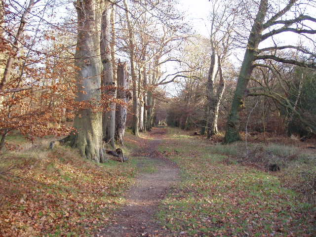
Avenue of beech trees in Berkhamstead common 19/12/05
OK, another embarrassing revelation - right where I meant to stop and turn round I missed a ‘Chiltern Way’ marker and took the wrong path for a few hundred yards before realising my mistake. Doh! My excuse is that I was distracted by some cows and bullocks in the adjacent field, who were following me as I walked along the woodland path on the other side of a fence from them. Well, that’s my excuse and I’m sticking to it! Incidentally, earlier this year I saw a herd of over eighty Fallow Deer in this field - that beat my previous record count when I saw 61 deer in the woods very close to this field (It’s a very large field, presumably once part of the parkland of the nearby Ashridge House as it has the typical copses and odd trees here and there within it. Apart from a cottage and track in one corner, it is completely surrounded by beech woods).
I stopped for lunch on the way back seated on a small section of felled tree, by a field on the eastern side of the ‘Tring gap’. The walk back was very pleasant in the warm sunshine, interspersed with cooler sections in the many woods I passed through. I got back to my car at the surprisingly early time of 14:35. This was a thoroughly enjoyable walk, and like the previous day’s, was definitely one of the best on the whole Chiltern Way.
(Note that today’s mileages are possibly a little inaccurate. All the mileages I give are based on those in the Guide Book. I normally end each day’s walk at the end of a section in the guide book, so can just add up the mileages for each section I’ve walked to calculate the mileage for the day. Today I finished approximately 0.4 miles, by my estimation, into a 1.6 mile section between the B4506 and Little Gaddesden. Any inaccuracy will obviously be countered by a corresponding inaccuracy in the next walk, so the total mileage will still be correct.)
Total distance: 184.5 miles (each way)