Pete's Walks - Greensand Ridge Walk
If you are considering walking this route yourself, please see my disclaimer. You may also like to see these notes about the maps and GPX files.
Day 5 21/04/06 Haynes to Sandy (about 7.8 miles each way)
Parked in Haynes.
As I had a bit further to travel today, I didn’t start this walk until almost 10 O’clock. It was another overcast day, although by the afternoon it was very warm (I think this is the last time I’ll wear my Paramo gear that has served so well during the winter, it’s time to start wearing my lighter, cooler summer gear again). There was a slight amount of rain just as I was getting back to Haynes in the afternoon, otherwise it remained dry.
From Haynes, a clear track lead between arable fields to a road at Deadman’s Cross. There was just a bus stop here, with a few cottages further down the road. For some strange reason, Leaflet 3 of the Greensand Ridge Walk ends here, more or less in the middle of nowhere, rather than in Haynes where there were ample places to park – perhaps it’s because there’s a bus stop here, to encourage people to use public transport, although surely there’s a bus service to Haynes. The leaflets don’t explain why it’s called Deadman’s Cross – curiously, I crossed the A6 on my previous walk at a place called Deadman’s Hill (the scene of the notorious Hanratty murder case in 1961).
At this point, there are two alternative routes for the Greensand Ridge Walk. The official route, shown as such in the leaflets and also on the OS map, follows a series of minor roads for about three miles. The alternative route, which is the route recommended in the leaflets, is a permissive path, opened by agreement between the council and the landowner, but it is not available between November 1st and March 1st. The permissive path goes in more or less a straight line to where the two options come together again, and is less than half the distance of the road walk. I normally try to walk every possible alternative route when I do these long-distance walks, but I have to say that I just didn’t fancy a three mile road walk (it would have been by far the longest section of road walking I’d have done on any of the long-distance paths I’ve done so far). I thought of compromising by doing the road walk on the way out and using the permissive path on the way back, but when I got to Deadman’s Cross my shins were a bit sore (this happens sometimes at the start of a walk) and I knew the road walk wouldn’t do them any good, so in the end I stuck to the permissive path both ways. I don’t think I missed much by not doing the road walk (the leaflets certainly don’t mention anything). Having measured the distance on the map, and judging by how long the walk took, I’m pretty certain that the mileage given in the leaflet is based on walking the permissive path rather than the roads, so I think the mileage I’ve given for this section is reasonably accurate (I’ve allowed 0.3 miles for the distance between Haynes and Deadman’s Cross).
The permissive path started out from the road alongside a hedge, to reach a kissing gate that gave access to Warden Great Wood. Here the route followed a well made track [1] (bits of brick and concrete visible below the dirt) through what is obviously a commercially managed wood (the trees were well spaced out in an orderly but unnatural fashion). The wood was a mixture of deciduous and coniferous, some parts purely one or the other but some parts mainly deciduous with a few pine trees or other conifers mixed in. It was a very pleasant walk through the trees, with plenty of visible and audible evidence of numerous pheasants. At the end of the wood, the good track continued through a field of stubble (passing one of the largest haystacks I’ve ever seen) before entering Warden Little Wood (again a commercial wood, I came across a tractor loading logs on to a trailer when I came back in the afternoon). On the far side of this smaller wood, the track passed a cottage and then continued for a few hundred yards beside a hedge to reach a minor road (where the road walking alternative route came in from the right).
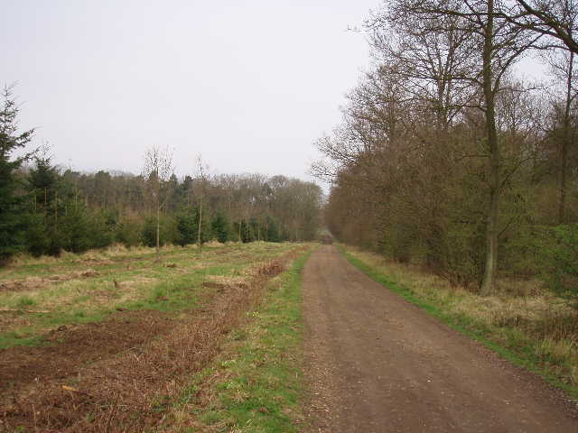
[1]Permissive path through Warden Great Wood
A good track, now a public bridleway, continued on the other side of the road. After a hundred yards or so I met a walker coming the other way, with whom I chatted for several minutes – it was very pleasant and most unusual for me to talk to another walker, it’s surprising how few I come across on these paths. He was doing a 30 mile walk – he belonged to the Long Distance Walkers Association, and did things like 50-mile challenge walks or 100-mile walks in a week-end. He said that the local group of the LDWA had social walks that were usually less than 20 miles, so I said I might possibly be interested in those. But I explained that I wasn’t really interested in challenge walks, I get pleasure from being in the country and seeing the wildlife and so on, I don’t really do walks as a physical challenge – the 15 mile walks I do are enough of a challenge for me, anyway! I do understand why some people do challenge walks though, I guess it’s a bit like running marathons, but it’s just not my cup of tea.
At this point, there were again good views to my left from the greensand ridge over the flat area around Bedford [2]. The huge airship hangars at Cardington were the most prominent things in view. A bit further along the track I passed a narrow belt of scrubland, which covered a disused railway tunnel (the line of the old railway was clearly visible heading towards Bedford in the distance). This area was now a nature reserve, managed by the local Wildlife Trust, and I read an information board about the wildlife and flowers that were there. It said that the old railway tunnel itself was bricked up, but with holes for the bats that nested in it.
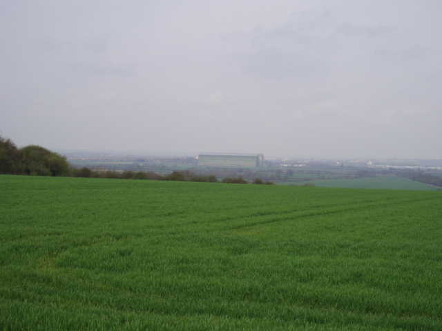
[2]View towards Bedford from the greensand ridge - the huge building is an airship hangar at Cardington
The good track continued along the ridge, but soon switched to the right of a hedge so the views towards Bedford were lost. Here I passed the first two fields of Oil Seed Rape that I had come across on this walk (in fact the first ones I’ve seen for a very long time). Near an isolated farm, the track crossed a footbridge through a hedge and then continued in the same direction (slightly north of east). The hedge on the left became a thin belt of trees, where I was startled by a pair of Muntjac deer running out just yards in front of me on my return journey. Near a cottage, the Greensand Ridge Walk took a footpath on the right that followed a headland between fields downhill. It passed through a belt of trees, and then crossed a sequence of three or four horse paddocks surrounding Highlands Farm – an impressive Georgian building that during World War II was home to German prisoners of war who worked on local farms.
The path then took me along the edge of a ploughed field beside a wood, which it then entered. This was Home Wood, which on its far side contained a rare network of mediaeval fishponds within a moat-like feature (from the path, I only saw part of the moat). The leaflet said that there was a bank within the moated area, thought to be a rabbit warren, thus providing a ‘living larder’ for the Lords of Northill Manor. From the far side of the wood (where there was another plaque commemorating the Queen’s Golden Jubilee, this one on a wooden stump with a Hare carved on it), a fenced and hedged track led between more horse paddocks to a shared driveway that led to a road in Northill.
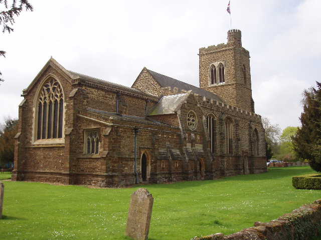
[3]Northill Church
As with all the churches I’ve passed on this walk, the impressively large 14th Century Northill Church [3] was built out of the local sandstone (I’m not sure why it’s called greensand as the stone is an orange-brown colour due to a trace of iron in it). There were several impressive Georgian houses in Northill [4], as well as several older thatched ones. From the outskirts of the village, I took a path beside a right-hand hedge, with a very large area of grassland on my left. On my way back, I saw two Grey Partridges here – this was quite a bonus, as I only see these birds once or twice a year, they are far less common than the Red-legged Partridge nowadays. The route for the rest of the way to Sandy was now very flat, the greensand ridge seeming to have petered out although I could see it rise again ahead of me immediately beyond Sandy. I continued along the clear path through arable fields to eventually cross a road.
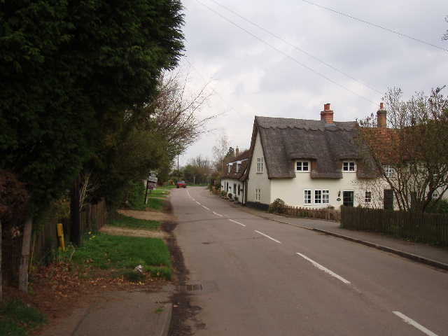
[4]Northill
Beyond the road, the way continued through a narrow avenue of young trees. Halfway along it, an information board gave details of the types of tree that had been planted, and explained which ones had there seed spread by the wind and which ones by wildlife (such as Jays hiding acorns). This was the first hint of what was soon to become very apparent – the residents of Beeston, the next village I’d come to, are obviously passionate about nature and wildlife. At the end of the avenue of young trees there was a large block of sandstone and another information board. This explained how the countryside here flourished because of the farmers, not in spite of them – one example was of how one particular wildflower came to be there because in the nineteenth century ‘shoddy’ (carpet waste) from Australia was spread over the fields as fertiliser.
The path lead on beside more flat sandy fields of potatoes or carrots, and then passed through a pig farm (which reminded me of several that I recall on the sandy soils in Suffolk where I used to live) to reach the large village green in Beeston. Here was another information board, with a plan of the green and a key identifying all the different types of tree that were planted around the green [5]. There were an amazing 39 types of tree there, many of which I’d never heard of before (Bastard Service Tree was the one I took care to look for, for some reason!) – there were at least three species of Willow, plus varieties of Maple, Hornbeam, Locust trees, Lime, etc., etc. It was very impressive, I just wish I’d had more time to take notes and to go round and look at all the individual trees.
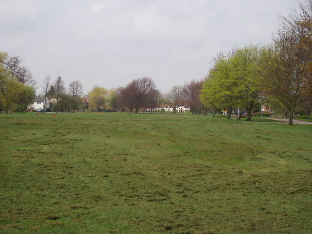
[5]Beeston Green
From the green, I followed a side road to an alley, then crossed the busy A1 dual carriageway on a very tall footbridge. I had to walk on the pavement beside the roaring traffic for about a hundred yards, before turning right down a road that became a paved footpath that crossed the River Ivel near a weir. Here another paved path led for several hundred yards on an island between two branches of the river, before another footbridge took me to a street that led me to the High Street in Sandy.
I turned and started to make my way back to Haynes. I sat on a bench on the green at Beeston to have a slightly early lunch, again admiring the impressive variety of trees. I enjoyed the walk back, especially with the sightings of the partridges and the Muntjac deer. I didn’t feel anywhere near as tired as I did on my last walk, fortunately, although I didn’t feel as good as I have on some other walks.
This was a really good walk that I thoroughly enjoyed. It was fairly flat, with just the descent from the ridge down towards Northill, but it had a good variety of scenery with some very pleasant woodland sections. I don’t think I’ve ever done a walk where I’ve come across so many interesting information boards before!
Total Distance: 34.8 miles each way