Pete's Walks - Hertfordshire Chain Walk
If you are considering walking this route yourself, please see my disclaimer. You may also like to see these notes about the maps and GPX files.
Walk 15 20/11/06 Ashwell Station to Therfield (6.5 miles each way)
Parked at Ashwell and Morden Station.
There was a lot of rain overnight, and I wasn’t 100% sure I’d walk today, it depended on whether or not the rain had cleared away as forecast. The skies were pretty grey as I drove to Ashwell and Morden railway station, but the rain had gone and the patches of blue sky that were visible gradually got bigger. Ashwell and Morden railway station is served by trains running between Cambridge and London King’s Cross. The station is actually in the hamlet of Odsey, but serves the villages of Ashwell (about 1.5 miles north-east of the station), Guilden Morden and Steeple Morden. The station is in Cambridgeshire, whereas the village of Ashwell is in Hertfordshire.
[1] Path heading uphill towards Gallows Hill from the A505
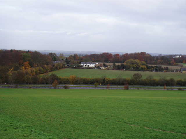
[2] Looking back across the A505 towards Ashwell and Morden station
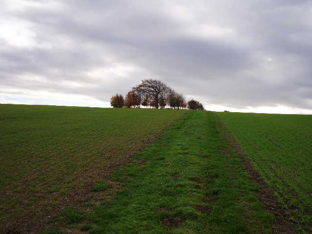
As with the previous walk, this final loop of the Hertfordshire Chain Walk is walked anti-clockwise. I started walking from the station at 10am, taking the road south for a short distance to the A505 dual carriageway. Safely across this, I continued in the same direction on a good track between open fields, rising steadily up Gallows Hill [1]. There were a few trees on the summit of this hill, round what was obviously a tumulus or ancient burial mound (confirmed by the map). There were good views from this hill [2], looking back over the vast expanse of flat land in Cambridgeshire and looking east along the low line of chalk hills towards Baldock. The track now continued in a south-westerly direction as it descended the other side of the hill to a farm. Here I crossed a lawn and squeezed through a gap between a fence and a garage to reach a lane, where I turned left to continue in a southerly direction.
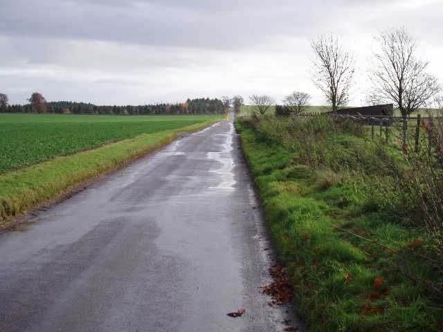
[3] The long lane walk
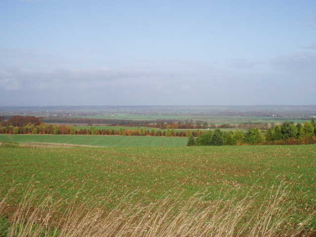
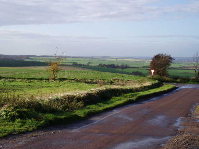
[4] View from where the lane reaches the top of the hill
I hadn’t been looking forward to this section of the walk, as I knew I had to follow the lane for over a mile [3]. It was almost all uphill in this direction too, though at a fairly gentle gradient. In the event, it wasn’t as tedious as I’d expected. There was a good verge on the left for most of the way, which had been fairly recently cut, so I alternated between walking on the grass and on the hard-surface. There were pleasant views over more open fields on either side, and I occasionally looked back to admire the view over the lower-lying land behind me. The skies were still mainly grey as I started up the lane, but by the time I reached the summit of the lane, where it turned left at a junction, the sky was predominantly blue and the sun was shining brightly. The views out over Cambridgeshire were now really impressive [4], and there was another good view along the ridge of chalk hills westwards towards Baldock. I followed the lane to the left, and shortly after a junction on my left I turned right onto a footpath [5,6].
[5] Looking towards Baldock from where the footpath leaves the lane
[6] View from where the footpath leaves the lane
The footpath followed a hedge on its left [7], soon descending gently into a dip where I went through a kissing gate into a grassy paddock. The path went uphill across the paddock and through another kissing gate into a field of long grass. I followed the visible track through the grass, passing to the left of a lone dead tree. On the other side of this field, two kissing gates in quick succession led into another paddock. Beyond this, the path turned half-left across a muddy yard by some stables, then crossed a paddock where a small brown horse was grazing (it came up to me when I came back this way, and let me stroke it – I wondered if it could smell the apple core in my rucksack). After another small paddock beside a bungalow, the path reached a farm drive, where it went left for a few yards to reach a lane in Kelshall.
I recognised where I was straight away, as almost opposite me was the village green [8], with the base of a mediaeval cross and a modern cross erected to celebrate the Millennium. The green here must be one of the tiniest in the country, as it is just a small triangle at the junction of two lanes. One of the very informative notice boards around the modern cross mentioned that walkers could once again rest here, and I had stopped here for my lunch on the first day of my Hertfordshire Way walk. I quickly decided that I’d try to get back here for lunch again today – it would somehow tie my two Hertfordshire walks together.

[7] View back from path to Kelshall
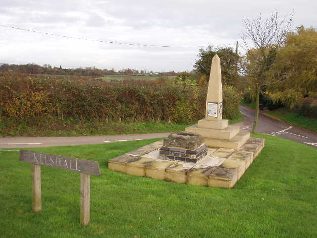
[8] Village green in Kelshall
From the green, I took the lane ahead of me for a short distance until it turned right. Here I continued on ahead on a path across a ploughed field – this was one of the fields where the path hadn’t been reinstated that I’d had to cross on my previous walk. When I reached the earth bridge over the ditch separating this field from the next ploughed field, I had to turn slightly left instead of continuing on the unmarked path I’d used on Saturday. Fortunately, this path was visible and had obviously been quite well-used so my route across this field was not so muddy. On the far side of the field, where there was a nice view ahead towards Therfield church surrounded by trees [9], I turned left alongside the hedge. At the field corner, where a bench was situated facing across the field towards Kelshall, I went through the hedge and turned right on a path, immediately going through a second hedge, then turned immediately left through a third hedge. I was now in the corner of a grassy field, which I crossed diagonally half-right to the far corner, near to a Water tower ahead of me (a Green Woodpecker flew off as I started across this field). I then took a track which ran between the Water tower on my left, and the very impressive half-timbered Tuthill Manor on my right. I was now back on the route of the Hertfordshire Way. Where the track ended, I turned right on a lane for a few yards, before turning left on a footpath.
I’d been looking forward to walking this path again, as I’d enjoyed it on the Hertfordshire Way. Observant readers (note that I have this fond delusion that at least two people read this drivel!) may notice that I’m being a bit inconsistent here - on my last walk I complained that I’d walked some parts of it before, now I was looking forward to walking a path again! I guess the difference is that on the previous walk I’d walked some bits twice before (on the Hertfordshire Way and on the Icknield Way part of my Bucks-Essex walk), whereas here I’d only walked the path once before. I’m usually quite glad to come across a path I’ve walked before, seeing it as like meeting an old friend, but I guess that after walking a path twice in both directions it becomes a bit boring to do it a third time.
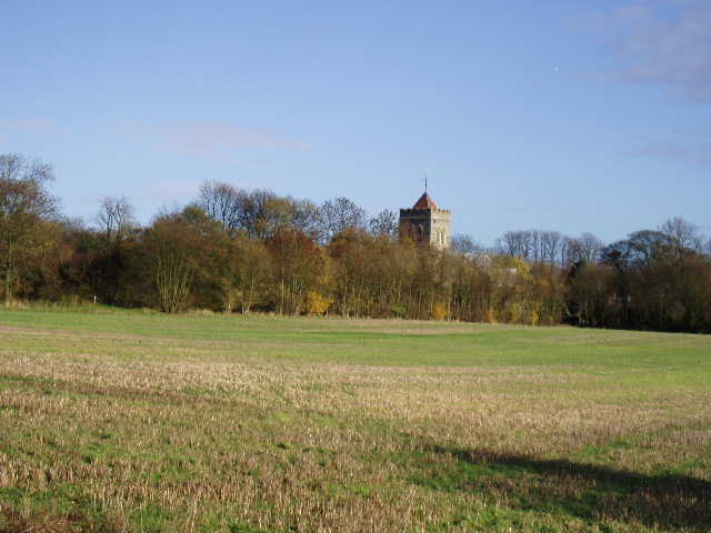
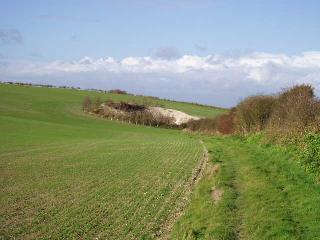
[9] View towards Therfield church
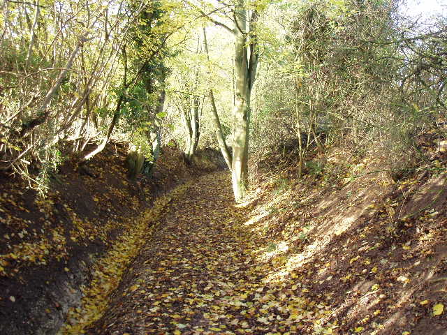
[10] Steep footpath leading north from Therfield
Anyway, the path led quite steeply downhill [10], heading northwards back towards the A505. The path was a sunken lane with steep banks and hedges on either side, and a deep drainage ditch to the left of the path that had been re-dug relatively recently. This showed that the topsoil was only about eighteen inches deep, with the solid chalk layer underneath. The path and ditch were both littered with fallen leaves. At the foot of the steep slope the path emerged into the corner of a vast open field, and followed a left hand hedge for a few yards before crossing the open field on a narrow band of grass. I saw some more speedwell here. The soil in the ploughed field here was very pale because of the chalk content, whereas the ploughed fields I’d crossed earlier had consisted of a rich dark brown earth. The path gently descended a shallow valley, heading towards Thrift farm in the distance. The path reached a hedge on the far side, and followed it for a few hundred yards, before passing a rifle range on the left [11]. A few hundred yards farther on, about quarter of a mile before Thrift farm, I came to a path junction where the Hertfordshire Chain Walk forked left. There was no sign of a path, but I could see the stile a long way off on the far side of the field and walked towards it in a straight line. On my return trip, I carefully trod in my old footsteps across this ploughed and planted field, so that I only left one set of tracks. The next field was a very large paddock grazed by three horses, and I continued on in the same direction across two or three more paddocks – in the last one, a large horse, something akin to a shire horse, approached me but then seemed to take fright and retreated to a corner. Beyond this last paddock, the path went down a grass strip close to a bungalow, and then continued on grass beside a driveway to reach the A505 dual carriageway.
I managed to cross this safely and without having to wait too long for gaps in the traffic. On the other side I continued northwards along a farm drive (each time I walked this section, a vehicle came up behind without me noticing until the last minute, because of the traffic noise from the A505 – on the way back a car driver had to sound his horn because I hadn’t heard him behind me). The farm drive went under the railway line, which runs parallel to the A505 here – I just missed being ‘run over’ by a train each time I went under the bridge. Immediately beyond the bridge I turned left along a path at the foot of the railway embankment, with another large ploughed field on my right. After a few hundred yards, the path started to run between two parallel wire fences [12] – at this point the embankment had gone and I was level with the railway track. There were bushes behind each fence that overgrew the path in places, so I was walking along here with my hands in front of my face pushing berry-laden branches out of the way (mainly hawthorn but some blackthorn too, I think). After following the railway for about a mile, I went passed the entrance to a chalk quarry , and went through a gateway on the left along a track heading towards Ashwell and Morden station.
Here the Hertfordshire Chain Walk had a curious sting in the tail. At the very last path junction I would come to on the route, the map and the guide book disagreed for the first time! The guide book said to continue ahead across the ‘crane yard’ to the station, but I was sure I’d seen on the map that the route went slightly north here and then turned left down the road to the station entrance. So I got the map out to check. Earlier on the Hertfordshire Chain Walk I complained about how the route kept switching between two maps – recently it has behaved itself and stayed on OS Explorer 194, but the last few yards into and out of Ashwell station were on a different map. Anyway, this definitely showed that the Hertfordshire Chain Walk went right at this junction. So I decided to compromise, and went right to follow the route in the map, but came back on the shorter route described in the guide book. Having forked right, I followed the path alongside a left-hand hedge to a field corner. There was no gap in the hedge there, so the path followed the hedge to the right for about a hundred yards to a gap and footpath sign. I then followed the road on the other side of the hedge back to the station. It was about 12.15 when I reached the station, thus completing the Hertfordshire Chain Walk in one direction.
[11] Footpath north from Therfield approaching the Rifle Range
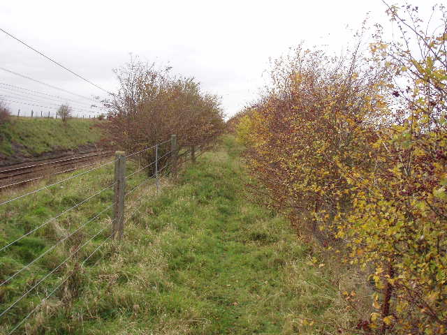
[12] Path alongside the railway line, heading towards Ashwell and Morden station
I enjoyed the walk back, although the steep climb up to Therfield was a little annoying as it came when I really wanted to stop for lunch about 1pm. But I pushed on to get to the village green at Kershall by about 1.25 – it just seemed somehow appropriate to have my last lunch on the Hertfordshire Chain Walk at the same spot I’d had lunch on my first walk on the Hertfordshire Way. It had clouded over a bit more now, though there were some patches of blue sky still visible. As I continued after lunch, the sky was divided roughly into two, with blue sky to the north ahead of me, and grey clouds behind me. The long walk back down the lane was actually quite pleasurable, as it was now downhill and there were the expansive views over Cambridgeshire ahead of me. By the farm buildings where I left the lane to take the path back to Gallows Hill, I noticed a sizeable flock of Collared Doves, a bird I see frequently but usually only in pairs.
This walk was far better than I’d imagined, possibly the lovely weather helped. I hadn’t been looking forward to it too much as I knew there was the long lane walk, the long stretch next to the railway and the muddy ploughed fields I walked on Saturday again. But in the event I really enjoyed it. The long walk up the lane was a bit of a drag, but not too bad, and coming back down was actually very good because of the lovely views. The railway section was fine and seemed to go really quickly, despite the problem with the numerous branches across the path. The first ploughed field still hadn’t had the path re-instated, but at least the path was clear in the second field (where I went a different way to the last walk). There were some terrific views from many parts of the walk, especially looking northwards over the lower-lying lands of Cambridgeshire.
On my way home I took a detour to drive through Ashwell (about a mile and a half from the station) as my parents had told me it was an attractive village. I was very impressed with it – it is quite a large village with many old buildings, and several short streets that obviously go back to the middle ages. The church is very large and impressive, with a short spire on top of a tower, and there was a village museum housed in a half-timbered building. I didn’t have time to stop, but I’d certainly like to go back to explore Ashwell sometime in the future.
Total Distance: 86.75 miles (each way)