Pete's Walks - Bernwood Jubilee Way
If you are considering walking this route yourself, please see my disclaimer. You may also like to see these notes about the maps and GPX files.
Day 1 1/2/07 Brill to Marsh Gibbon (8.4 miles each way)
Parked in Brill.
I was a few minutes late setting off from home this morning. It took about an hour to drive to Brill, and so I didn’t actually start walking until around 10.20am. It was sunny when I left home, but I noticed a grey cloud ahead of me as I drove westward and by the time I reached Brill the sky was almost overcast.
Brill is situated at the top of a hill, one of three or four that rise quite steeply out of the Vale of Aylesbury hereabouts – the adjacent hill to the west is called Muswell Hill. Throughout the middle ages, Brill was the most important settlement in the Forest of Bernwood, with a royal palace, fish ponds, mills, church, prison, market and fair. Later on it became a prominent centre of pottery, then a centre of brick and tile production. Brill was a royal centre from Saxon times, although its history may go back much further, its position and its curving road pattern indicating that there may have been an Iron Age hillfort here. Edward the Confessor built a hunting lodge here around 1050 (one of his claims for Sainthood was that he cured a workman building the palace here of blindness). The palace remained important for sometime after the Norman Conquest – Henry I signed a charter here, and both Henry II and Henry III occasionally kept court here.
In 1642, a Royalist garrison in Brill was attacked by Parliamentary forces under John Hampden (Not him again! I went past his home at Great Hampden on the Chiltern Way, and Great Kimble church on the North Bucks Way and Aylesbury Ring is also associated with him). The attack was repelled with considerable loss, but the garrison was evacuated the following year. The earthworks visible today may be due to these Civil War activities rather than to the royal palace.
[1] View of Muswell Hill from Tramhill on the edge of Brill
[2] View over Vale of Aylesbury and Waddesdon from Tramhill on the edge of Brill
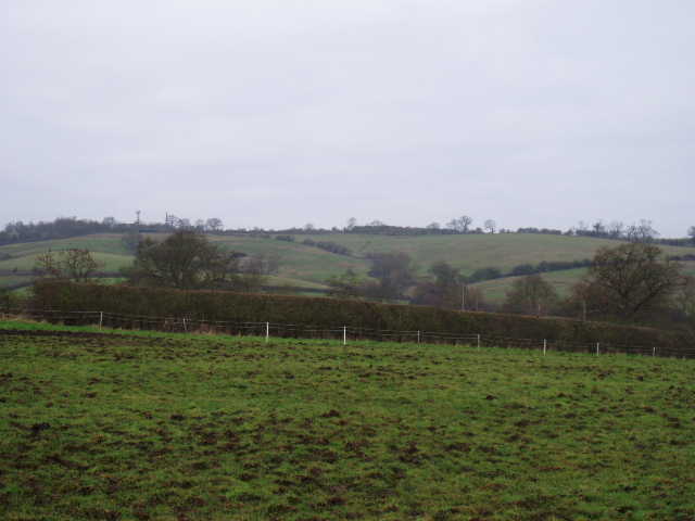
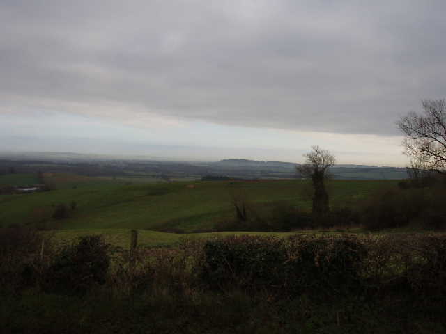
For some reason, I couldn’t be bothered to find the commemorative stone and plaque marking the official start and end point of the Bernwood Jubilee Way and decided to leave that to when I get back to Brill in a few weeks time. Instead I just headed north out of Brill along a road called Tramhill (I would be walking generally northwards all the way to Marsh Gibbon). On the edge of the village, by Temple farm, I stopped to admire the views. To the west I could see the neighbouring Muswell Hill [1], while northwards I could see for miles and miles over the very flat Vale of Aylesbury. I could also see where Waddesdon Manor, a Rothschild home now run by the National Trust, was situated on its hilltop a few miles eastward [2] – I will be passing close to it on this walk in a few days time. I continued along the road, descending quite steeply. This would be the only real hill on the entire walk (so coming back up it at the very end of the walk was a bit of a bind!). The road, Tramhill, gets its name from the Brill Tramway, originally built by the Duke of Buckingham and Chandos to serve his estates around Wotton Underwood and ending its life as a branch line of the London Metropolitan Railway.
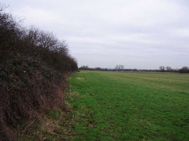
The road ended at a T-junction at the foot of the hill, where I crossed over and continued northwards on a footpath. This followed a right-hand fence beside some paddocks, then followed a hedge through a couple of sheep pastures (I passed a dead sheep in one of them) to reach a corner of a wood. Here there was a notice board about the mediaeval hunting forest of Bernwood, and in particular about the Open Field system of farming and how it has left a legacy of parallel ridges and depressions known as ‘Ridge and Furrow’ (there is a very detailed description of Ridge and Furrows in the guide book). This part of Buckinghamshire has some of the most extensive remains of Ridge and Furrow in the Midlands. The path continued onwards through another sheep pasture [3], with Rushbeds Wood on my right (it is a nature reserve run by the Berks, Bucks and Oxon Wildlife Trust). The wood is ancient woodland, around at the time of the hunting forest and was formerly known as Rushbeds Coppice (coppicing would have provided straight poles for such crafts as fencing and turnery). I didn’t notice it until I came back this way, but there was evidence of the regular pattern of dips and rises indicative of the Ridge and Furrow system in this field (perhaps I only saw it in the afternoon because it was sunnier and the shadows made it easier to see).
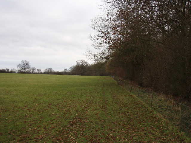
[3] Path alongside Rushbeds Wood
The next field was empty grassland, and half way across it the Bernwood Jubilee Way veered away from the wood. Double stiles led through a hedgerow, and the path crossed the next empty grass field diagonally half-left to a corner where a tall hedgeline marked the course of a railway line. As I crossed this field I both heard and saw Red Kites over to my left! Ironically, three days ago I had driven all the way to Hambleden (near Henley-on-Thames) to do a walk where I knew I’d be able to see some Red Kites for the first time this year. (It was a great walk anyway, and as well as lots of Red Kites I saw a herd of 180 Fallow deer, with two smaller groups of 20-25 a little further on).
Through the gate in the field corner, the Bernwood Jubilee Way turned sharply left (westwards) to follow a rather muddy bridleway for about half a mile. I saw the kites again as I went along here (I had even better views of them soaring overhead when I came back here in the afternoon). The bridleway passed one farm where a small black dog barked at me as I passed the ducks and duck pond – curiously the same dog completely ignored me when I went back the other way. The bridleway then joined the tarmac drive to that farm, and soon passed a second farm (Poletrees farm). I turned right at the end of the drive, but soon left the road, taking a path on the right over a stile. This crossed a corner of grassland by Poletrees farm to a second stile, then crossed a very large and empty sheep pasture, rising and then falling over a slight undulation (the nearest thing to another hill that I’d come to on this walk). Two or three more muddy grass fields took me back to the road by a bridge over the railway line, which took me into the village of Ludgershall.
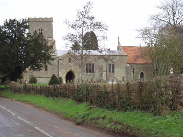
[4] Ludgershall church
I followed the road through the village. Just before reaching the church [4], I saw an empty moat in the field on my left. Traditionally Ludgershall is associated with the semi-mythical pagan King Ludd (who is said to have had a royal palace at Brill), and this piece of land is described as the site of King Ludd’s hall. I continued through the village, turning left at a junction. Over to my right was D’Oyley farm – by coincidence, after my walk three days ago I had a look round Hambleden church, which contained a memorial to the D’Oyley family. I wonder if there is a connection. On the edge of the village, I crossed a plank bridge and a stile into a very muddy field. Around the far side of the stile, the mud was very sloppy and almost ankle deep – I had no option but to wade round the edge of it, close to a farmyard. Fortunately, after a few yards things improved, although the rest of this huge empty field of rough grass was still very damp underfoot. I managed to follow a curving track that led towards the far left corner of the field – possibly there were feint signs of Ridge and Furrow here too, as there were puddles of water regularly spaced along this track with fractionally higher firmer ground between them.
The path continued alongside a left-hand hedge in the next empty field, then passed along a narrow strip between a left-hand stream and a farm. I continued, still heading north, through a further succession of three or four large empty grass fields [5], the only distinguishable feature being a row of giant electricity pylons that I passed under (I’d seen the row of pylons from Brill, a very obvious blot on the landscape as they marched across the Vale of Aylesbury). According to the map, the path should have switched to the other side of the hedge at some point, but in fact it continued on the right of the hedge all the way to the A41 (the Roman Akeman Street). Here I turned right for about a quarter of a mile (fortunately there was a pavement alongside this busy trunk road), before turning left on a footpath across another grass field. I didn’t realise when I started to cross it just how wet this field was going to be – on the way back I chose to follow the permissive path round the edge of the field. As I squished my way across, a flock of 20-30 small birds flew up out of the long wet grass – they were obviously something unusual, not one of the birds I normally see on my walks, but annoyingly I didn’t have my binoculars with me, and having now checked my bird books, I still don’t know what they were.
[5] One of numerous empty sheep pastures between Ludgershall and Marsh Gibbon ...
Halfway across this field I crossed from the area covered by one map (OS Explorer 180) to that covered by another (OS Explorer 192). I did a really stupid thing this morning. I brought both maps and the guide book down from my bedroom to the hall, carefully folded the first map I’d need and put in my map case, then picked up my rucksack and went off, leaving the other map and the guide book behind! Fortunately, the Bernwood Jubilee Way is very well marked with waymarks and signposts, so I was able to follow the route the rest of the way to Marsh Gibbon despite having any map or other form of guidance. The path continued onwards, following a left-hand hedge through two or three more empty green pastures to reach a lane where I turned left. I phoned home and asked my mum to check on the map I’d left behind, as I couldn’t remember which way I should go – there was a Bernwood Jubilee Way signpost pointing left, but I’d already seen one or two beside roads that had been twisted to point the wrong way. She confirmed I was going the right way, and after about half a mile down this long straight lane I found a sign and stile on the right.
I followed a right hand hedge through a couple more empty green fields, then went over two stiles to pass through a hedgerow (this is not a walk for people who don’t like stiles, as there were many double stiles on the route). Here I wasn’t quite sure were the footpath went – there was the smallest of stiles crossing a wire fence in front of me (nothing like a normal footpath stile) into a green field, but the fence almost immediately turned in the direction I was going and there was a clear path between it and some recently planted young trees (protected from deer by plastic tubes). I followed the path, and as I did so about 20 sheep on the other side of the wire fence (there were three horses in there as well) ran over and started following me as I walked along. On the far side, the fence turned back left again so that the path came to a gate into the next field. The sheep all forced themselves up into the corner behind the fence, obviously still expecting me to give them something to eat. They did the same thing on my way back too – very strange, sheep usually run from me, they don’t follow me. Anyway I continued onwards across a huge sheep pasture (the sheep here behaved normally) and then another equally large one (there was another dead sheep here). There was much clearer evidence of Ridge and Furrow in this second huge pasture than anywhere else on today’s walk.
The Bernwood Jubilee Way then crossed over a farm track, and continued through another two or three much smaller sheep pastures [6] to reach a minor road. I followed this right for a short distance, then turned left at a cross-roads. Within a few hundred yards I reached the Village Hall on the edge of Marsh Gibbon, which was my turning point for the day. It had taken me about two hours and 45 minutes to get there. I had a quick swig of water, then turned and headed back to Brill. I hadn’t been to Marsh Gibbon before, but had seen it and passed very close to it on the Cross Bucks Way which I walked 12 months ago (my next walk on the Bernwood Jubilee Way shares part of its route with the Cross Bucks Way).
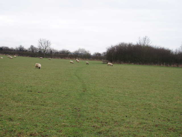
[6] ... and a sheep pasture complete with sheep, near Marsh Gibbon
I stopped for lunch on a stile about 1.30pm, just before I got back to the long straight lane. As I was about to turn off the A41, a car pulled up in the adjacent layby and the driver got out to talk to me. He was the owner of the land I was about to walk over and he kindly warned me that I might hear someone doing some shooting a little way on. He was a walker himself apparently – he and his wife once walked about 280 miles on the Southwest Coast Path in eleven days! Some going! I did hear someone shooting, but had no problem going back that way – I saw a Muntjac deer running along the hedgerow in front of me, then turning left at the next field corner. I enjoyed seeing the kites again along the bridleway from Poletrees farm – I simply had to stop and admire them as they soared overhead at tree-top height. The climb up the hill at the end of the day was a bit of a struggle but not too bad – the views back northwards at the top made it well worthwhile, as it was now quite sunny so the views were even better than they’d been in the rather grey morning [7,8].
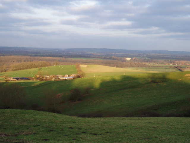
[7] View over Vale of Aylesbury from Tramhill on the edge of Brill (photo taken in afternoon)
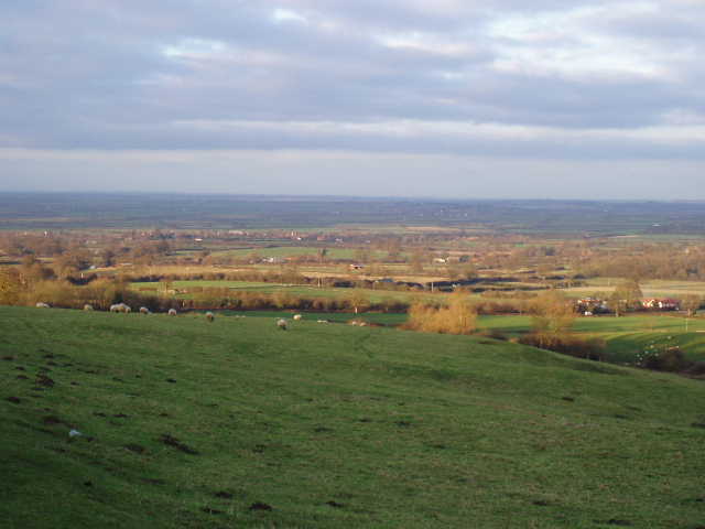
[8] View over Vale of Aylesbury from Tramhill on the edge of Brill (photo taken in afternoon)
The mud I encountered on this walk was of a particularly clingy type of clay – despite the fact that I ended the walk with about a half-mile stretch on roads or pavement, my boots were still caked in large amounts of mud when I got back to my car. I had to give them a really good clean and waterproofing when I got home – long overdue anyway!
This was not one of the better walks that I have done, even allowing for the very muddy conditions. Much of it was very flat (from Ludgershall all the way to Marsh Gibbon it was completely flat) and it was all very similar – a very long sequence of sheep pastures with very little variety. Some pastures were empty, some had sheep. Sometimes I followed a hedge on my left, other times the hedge was on my right. Sometimes the hedge had been trimmed, other times it had not. That’s about it as far as variety of scenery was concerned. As it was so flat, I could usually just see the four brown and bare hedges of the pasture I was walking through, only occasionally getting a glimpse of a far off hill. I was getting pretty bored with the endless sheep pastures by late afternoon, although the Red Kites and the final bit of uphill into Brill did cheer me up and make me think a bit better of the walk. At least the route was very well waymarked or signposted (just as well, for idiot’s like me who leave their maps at home!).
Total distance: 8.4 miles each way