Pete's Walks - Bernwood Jubilee Way
If you are considering walking this route yourself, please see my disclaimer. You may also like to see these notes about the maps and GPX files.
Day 8 11/3/07 Oakley to Brill (6.9 miles each way)
Parked in village hall car park in Oakley.
I parked at the village hall in Oakley, as recommended in the guide book. In fact, there was plenty of parking space along the side road that I reached on my last walk, so I could have save myself five minutes walking at each end of the walk.
It was a nice sunny morning as I started walking about 10.10am. I followed the side road that I’d reached last time, turning right just before its end and then almost immediately turning left down an alley to reach the playing fields by the village hall. I turned left for a few yards to cross a stile in the corner – on the other side of the stile was a really muddy patch that was unavoidable. I turned right alongside the hedge – the grass in this field was a bit squelchy as I walked along, but not as wet as some of the pastures I’ve walked through recently. I was heading south or southwest, despite the fact that Brill is to the north of Oakley. There was another area of wet mud in front of the next stile, and again the subsequent larger pasture was a bit wet underfoot in places. On the far side I crossed a new gravel track (used by the lorries going to the landfill site I would soon come across), and then turned half left through a former field that had now been planted with young trees. I heard the distinctive sound of a peacock coming from Jericho farm to my right. I could also hear the less pleasant sound of the traffic on the nearby M40 motorway.
[1] Path from motorway bridge heading towards Shabbington Wood
[2] Gate at entrance to Shabbington Wood
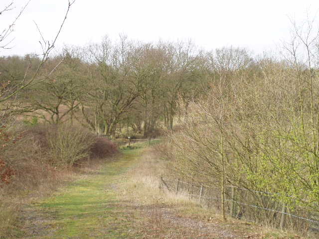
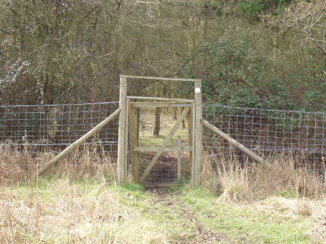
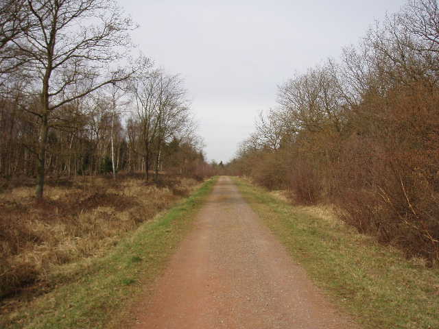
Having crossed the new plantation diagonally, I then had to re-cross the new gravel track. There was evidence all around me now of this area being used as a landfill site. The Bernwood Jubilee Way continued alongside a wood panel fence (one panel had been severely damaged by recent strong winds) and then ran between some bushes to reach a footbridge over the motorway. On the far side of the bridge was a nice view of some rough ground and then the trees of Shabbington Wood. The path continued for about a hundred yards or so [1], then turned left alongside the remnants of an old hedge to reach the edge of the woods. A gate in a wire fence gave access to the woods (like several over gates in and round these woods, instead of being vertical, the gate was angled forwards slightly) [2].
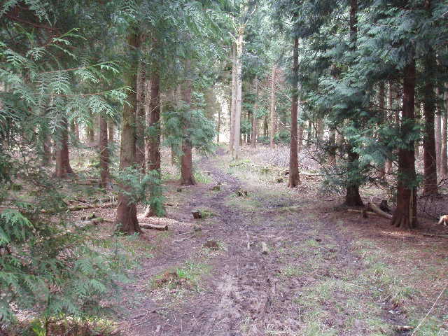
Despite its name, Shabbington Wood is now in the parish of Oakley. Alongside the adjoining Oakley Wood, it represents the largest remaining area of the ancient Bernwood Forest. However, little of the semi-natural ancient woodland remains, much of the modern wood having been replanted mainly with conifers. The first path I followed through the wood [3] was through an area of mainly Lawson’s Cypress (according to the guide book). I had to find my way round a couple of fallen trees, more evidence of the strong winds we experienced before and after Christmas. I soon came to a junction where the Bernwood Jubilee Way went half-left, now with a small area of beech trees on my right. I then went through another gate into another section of the wood, a mixture of conifers and deciduous trees [4]. The path was now rather muddy, but nowhere near as bad as some paths I’ve walked recently. I saw a small yellow flower here on my way back, which I later identified as a Lesser Celandine. After a few hundred yards I came to a junction, where I turned right along a gravel track. I had to check my map here, as there was no Bernwood Jubilee Way waymark and the guide book mentioned a large ride rather than a gravel track.
[3] Path through Shabbington Wood
[4] Path through Shabbington Wood
[5] Track through Shabbington Wood
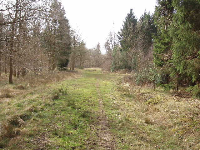
A short distance along the gravel track, I spotted two Fallow Deer a few yards away to my right. They started running back the way I’d come, then turned to run across the track and disappear into the trees on the other side. A little further on I saw a group of parked 4x4 vehicles, and some people wearing safety helmets and carrying climbing ropes. It appeared that someone from the Environment Agency was giving some training, explaining how to safely use ropes to climb trees (presumably for inspection and trimming purposes). I carried on along the gravel track [5] – it reminded me a little of tracks I used to walk in Rendlesham Forest in Suffolk. By a crossroads of tracks I saw an information board, about the woodland and about coppicing in particular. The woods are a Site of Special Scientific Interest – the common Dormouse can be found here, as can several types of rare butterflies. These latter include a number of different varieties of fritillaries - Pearl-bordered, Small pearl-bordered, High brown, and Duke of Burgundy – as well as both Brown and Black Hairstreak butterflies. Sadly I didn’t see any butterflies at all today – disappointing as yesterday I’d seen Brimstones both in our garden and on a local walk.
I continued ahead on the track for a few more hundred yards, until some waymarks indicated a crossing public footpath. Again there was no Bernwood Jubilee Way waymark, but this was obviously where I needed to turn right – the map showed no other crossing footpath, and this one ran beside a stream, as shown on the map and mentioned in the guide book. I followed the path with the stream (in reality more like a muddy ditch) on my right, and an open area of rough grass in the middle of the woods on my left. The path was very muddy in places, causing me to take one or two very short diversions to avoid the worst stretches. The path passed through another angled gate (very sloppy mud was unavoidable here) and eventually re-entered the trees (I was now in Oakley Wood rather than Shabbington Wood). The path ended at a wide grass ride where I turned left. In fact the ride was more mud than grass, and the first couple of hundred yards or so were slow going, but it gradually improved.
Where the wide ride turned to the left, I continued ahead on a narrower and drier path, but after a couple of hundred yards or so this came to a dead-end – the rickety remains of a wooden bridge, partly overgrown by brambles, led to a barbed wire fence surrounding a field. I checked the map and the guide book – in fact, the Bernwood Jubilee Way doesn’t follow a footpath at this point, it simply follows a parallel course to the wire fence, just inside the woods, to reach a road. Fortunately, at this time of year there was little in the way of undergrowth, so it was not too difficult ‘bushwhacking’ through the trees. There was no evidence at all of any path, although I saw an occasional footprint. I also saw a Muntjac deer in this corner of the woods. The fence and field beyond served as a safe guide, and I soon emerged on the road, where I turned right.
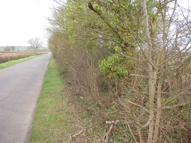
[6] Ancient hedge marking the Boarstall-Oakley parish boundary
I now had about a mile of road walking ahead of me. In the distance ahead of me I could see Muswell Hill, a grassy eminence dotted with sheep. It’s neighbour, and my destination, Brill Hill was hidden from view for most of the time by the high hedge on my right [6]. I’m sure I wouldn’t have noticed if I hadn’t read the guide book, but this hedge was quite interesting – it is possibly up to a thousand years old. It forms part of the parish boundary between Oakly and Boarstall. Its great age is determined from the fact that the ditch is on the field side rather than the road side of the hedge, from the fact that the hedge is on a raised bank, and finally from the fact that it contains many woodland indicator species, in particular a high number of Field Maple trees. After passing a large farm on my right, the road soon crossed the M40 and almost immediately after I took a fork going left. There was another wood now beyond the field on my right, and I saw a couple of large birds over the woods – probably Buzzards rather than Kites, I didn’t have my binoculars with me today.
[7] View towards Muswell Hill from near Boarstall
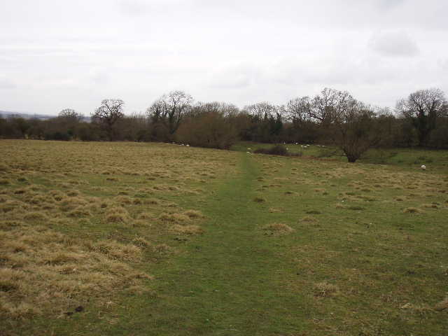
Having passed a row of cottages in the hamlet of Honeyburge, I finally finished the lengthy section of road walking by taking a footpath on the right. This crossed the corner of another wet grass field and then followed the right-hand edge of the field beside the wood I’d seen earlier. The next field had been ploughed – the path across it had not been reinstated, so I followed the edge of the field instead, still alongside the wood. Here I saw another large bird soaring above me, this time clearly a Buzzard. There was some Common Field Speedwell along the field edge. I continued alongside the wood in the next grassy field. Only about a hundred yards from the far side of this field, I turned left by a signpost to cross the field, actually heading back on myself slightly. I aimed at a gap in the far hedge, with a waymark clearly visible beside it. I saw my first hare of the year as I crossed this field, running away over to my left. I continued on the same line through the next grassy field, then followed the waymarked path through a small copse. The Bernwood Jubilee Way then continued on a grassy strip next to a right-hand hedge [7].
[8] Looking back along the path, from near Boarstall
It had been sunny and bright when I started out, but now it had clouded over and the skies were grey and gloomy [8]. I wondered if the forecast was wrong and it was going to rain. It had cooled down a bit too, but I was grateful as a little while earlier I’d been feeling too warm. I also felt a bit unenthusiastic about the walk at this point for some reason – possibly it was the gloomy conditions, perhaps it was the tortuous elongated ‘S’ shape that the Bernwood Jubilee Way took hereabouts, meaning that I was walking a long way to get not very far – and at this point I was actually walking away from Brill! (The whole of this seven mile walk followed a very roundabout route – it’s actually less than 2 miles from Oakley to Brill by car).
The next field had been ploughed and again the path had not been reinstated, so again I followed the wide grass strip round the right-hand edge of the field to the far corner – at least this gave me the chance to see the adjacent moated site, which I’d not have seen if I’d walked across the middle of the field. The four sides of the moat were quiet obvious, although the whole area was covered by thorny bushes. On the far side of the field, I went over a stile onto a road, opposite the village church of Boarstall. I turned right to follow the road through the village.
Almost immediately, I passed the entrance to Boarstall Tower [9] – there was another information board here (and a ‘Millennium bench’ which is where I ate my sandwiches on my way back). Boarstall Tower is the gatehouse of a fortified manor house, probably built in the 14th century. No other buildings remain on the site, the last other remnants being demolished in the late 18th Century. The tower was updated in 1615 for use as a banqueting hall, and was then fortified as a royalist garrison during the Civil War. Boarstall Tower is the only complete mediaeval fortified building in Buckinghamshire, and is now run by the National Trust (although it was not open when I went past, like most NT properties it will open again in a few weeks time).
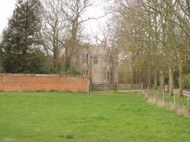
[9] Boarstall Tower
I followed the road past the few properties in this small village, then turned right onto a footpath almost opposite a farm. I followed the right-hand hedge of a grassy field (where I saw another hare on my return). Over a stile, I continued beside a left-hand hedge of an arable field, then another stile led to a very short path through a small clump of trees to a road junction. I took the road opposite, signposted Brill 2½ miles, hoping that my route would be shorter than that. I had to follow the road eastwards for about 2/3rds of a mile, with the slopes of Muswell Hill immediately to my left. Shortly after I started down the road, I saw two large birds on the hillside, which I thought were Red Kites from the length of their tails and the width of the wings. When one of them soared straight towards me rather than away from me, this too made me think it was a Kite rather than a Buzzard and sure enough I could soon see its forked tail and chestnut red colouring. It circled overhead three or four times, not as low as some Kites have done, seeming to follow me as I walked down the road before heading back over the adjacent sheep pasture. The other bird may have been a Buzzard though, as I saw four of them here when I came back.
Just beyond a cluster of houses at Touchbridge, the road turned sharply left. Here I left it, and continued forwards on a footpath that crossed three sheep pastures as it gradually climbed Brill Hill [10] – the hillside was nowhere near as steep as it had seemed from a distance, but the ground was very muddy and slippy in places which slowed my progress. The path went round the side of a cottage to a track [11], where I could see Brill windmill [12] a short distance away. The mill is a listed building, and one of the oldest postmills in the country, dating from the 17th century. It was last used in 1919 for milling barley. At 615ft above sea level, Brill is an ideal spot for a windmill and it is thought that at one time there were five in the village.
[10] Looking back along the start of the path up Brill Hill
[11] Looking back towards Muswell Hill from the edge of Brill
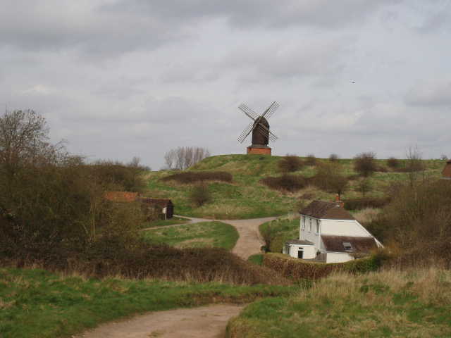
[12] Brill Windmill
I turned right along another gravelly track. A short distance along it I saw a footpath on my left. Checking the map and guide book, I wasn’t quite sure if it was the one I wanted or not but decided to follow it a short distance to see. When I tried top open the gate across the start of the path, I found that the bolt holding it closed was very stiff. Predictably, when I pulled the bolt really hard, it suddenly became free and shot back, causing me to cut my finger on the edge of the metal casing holding the bolt. Less predictably, and to add insult to injury, the sudden freeing of the bolt caused me to take an involuntary step back, and my right boot went into a small pool of almost liquid black mud. To cap it all, of course, when I went on a few yards I could see that this was not the path I wanted, so this mishap was entirely unnecessary!
A short distance further on, I came across the correct path. I stopped to put a bandage on my bleeding finger (only the second or third time I’ve needed to use the first-aid kit I always carry). The path led uphill again through an area of rough grass parallel to a line of houses, then passed some bungalows and went down a short alley to emerge on a road near the centre of the village. A road sign declared this to be The Square, although it was triangular in shape with three roads entering it. There was a triangular village green in the centre surmounted by a large stone cross [13]. I followed Church Street to reach All Saints church. Brill was the site of a royal palace in Saxon and Norman times, and the church was originally a private chapel for the palace, the villagers then having their own church near Oakley. Outside the church was a small stone with a plaque, marking the official start and end point of the Bernwood Jubilee Way. I had to carry on a little further, crossing the adjacent playing field and turning left down an alley to reach Tram Hill, where I had started my journey.
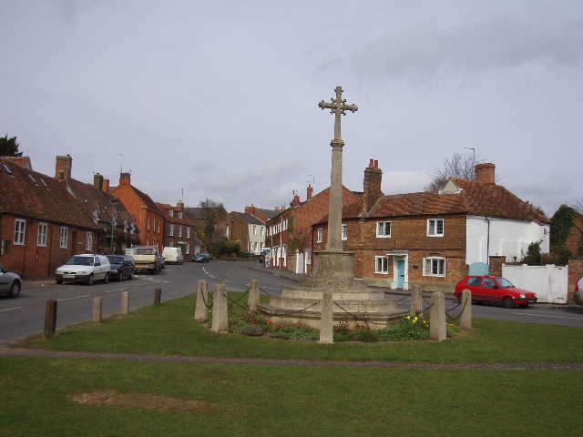
[13] Brill
It was 1pm as I turned round and started on my way back to Oakley. I decided I’d have yet another late lunch, and just had a second Alpen bar to keep me going. It was about 1.50pm when I got back to Boarstall, and finally had lunch seated on the Millennium bench outside Boarstall Tower. There was a nice view of Muswell Hill and Brill Hill from the bench, and for the second time today I heard the call of a peacock, coming from the gardens of the tower behind me. The grey clouds had now lifted and the afternoon was quite bright – there was a lot of very high and thin cloud, which gave way to more blue sky as the afternoon wore on. My earlier lack of enthusiasm also went, and I really enjoyed the walk back. I sometimes get a tune stuck in my head, and this afternoon it was ‘Samba pa ti’ by Santana (if you’re too young to remember it from the Seventies, it’s currently being used by Marks and Spencer in their food adverts. Sacrilege!). By the time I’d got back to Oakley, my head radio had moved on to another really great guitar song, ‘Freebird’ by Lynyrd Skynyrd (I think I managed to refrain from playing air guitar, but I can’t swear to that).
This was a very good walk, despite the mud and the fact that the path disappears completely just before the end of Oakley Wood. There was a nice mixture of woodland walking and field side paths, and although generally flat (except for the final short ascent of Brill Hill) there were some nice views over the open countryside, especially towards Muswell Hill and Brill Hill. There were a couple of long stretches of road walking though, but in both cases the roads were quiet and there were decent verges. Brill is an attractive and interesting village, and Boarstall Tower added some historic interest to the walk. I was very lucky with wildlife sightings today – Fallow deer, Muntjac deer, Hares, a Red Kite and several Buzzards. I also saw a couple of more common birds that I really like, Long-tailed Tit and Skylark. Sadly there was no Ridge and Furrow today – the only day of the Bernwood Jubilee Way that I haven’t seen it.
Total distance: 61 miles each way