Pete's Walks - The Hertfordshire Way
About the Hertfordshire Way
The Hertfordshire Way is a long-distance path that follows a circular route anti-clockwise through that county. It starts and finishes at Royston, in the North East of Hertfordshire, and passes through or close to Baldock, Letchworth, Stevenage, St Albans, Tring, Hemel Hempstead, Kings Langley, Potters Bar, Hertford and Bishops Stortford. Altogether, it is about 195 miles long.
The Hertfordshire Way was originally created by members of the Ramblers Association in 1994, as part of the celebrations of that organisations 60th anniversary. It is now maintained by “The Friends of the Hertfordshire Way”, although the Ramblers Association still give it financial support and encouragement.
“The Friends of the Hertfordshire Way” have produced a detailed guide book for the Hertfordshire Way (most historical or other facts that I quote in my journal are taken from this). The route is marked on the ground by special roundel waymark signs, and can be followed on the following OS Explorer maps: 173, 174, 181, 182, 193, 194, and 209 (Note: page 18 of the guide book wrongly refers to 192 instead of 194). On some of these maps the Hertfordshire Way is actually shown as a recreational path, on others it can only be followed as a series of footpaths and bridleways – the guide book is therefore essential to anyone wishing to do the full walk. (Important note: some of the maps show the old route of the Hertfordshire Way, which is different to that in the latest edition of the guide book!)
Note: When I did this walk, the route was only waymarked/signposted in the anti-clockwise direction, the same way as described in the guide book. But it has since been marked in both directions.
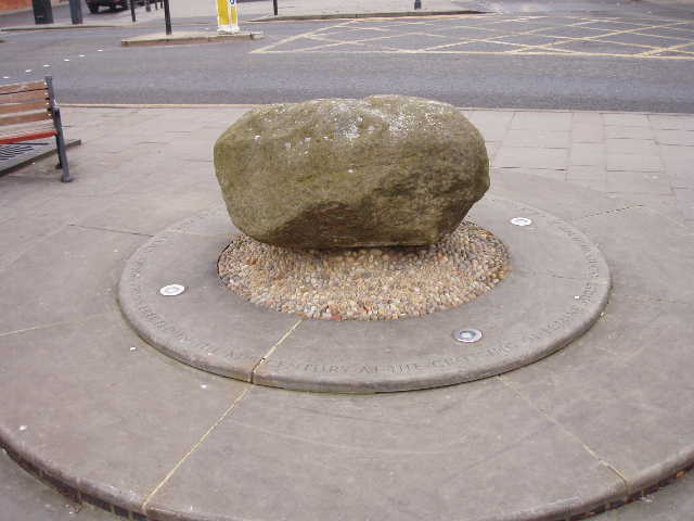
The Royse Stone in Royston marks the start and finish of the Hertfordshire Way. There is a hole in the top of the stone where there was once a cross. The cross was raised by a Lady Roisa to mark where the Icknield Way and Ermine Street crossed, and the settlement that grew up around the crossroads became known as Roisa's Cross, then Roisa's Tun (or town) and eventually Royston.
Click here to see a very rough map of the Hertfordshire Way (but only if you have already read my disclaimer and notes regarding maps).