Pete's Walks - The Hertfordshire Way
If you are considering walking this route yourself, please see my disclaimer. You may also like to see these notes about the maps and GPX files.
Day 1 26/09/05 Royston to Sandon (8.4 miles each way)
Parked in car park by sports centre on Therfield Heath on edge of Royston
I parked on Therfield Heath to save having to pay for parking in Royston itself, although this added a few hundred yards to the length of the walk. I started by walking along Baldock Road from the car park into the centre of Royston, where I read a notice board about the town’s history. A Lady Roisia raised a cross here in the middle ages, marking where two ancients roads crossed - the Icknield Way and Ermine Street. The place become known as Roisia’s Cross, then Roisia’s tun or town, and eventually Royston. There is also an interesting cave cut in the chalk, with possible connections to the Knight’s Templar. Only the stone that supported the ancient cross remains, and it marks the start of the Hertfordshire Way. Having circled the stone, much to the puzzlement of onlookers, I retraced my steps back up Baldock Road as far as the Golf clubhouse on the edge of Therfield Heath.
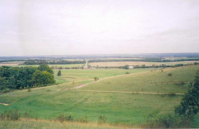
From Church Hill, looking out over Royston Golf Club and parts of Cambridgeshire
The Hertfordshire Way left the road at this point, and followed the left-hand edge of the heath past the clubhouse and steadily uphill, with a hedge and houses on the left and sports fields and a small valley on the right. The path continued to the top of the hill, where there were good views out to the flat lands of Cambridgeshire, and then went on the same direction, before turning round the head of the valley. Here it entered a narrow wood, which continued to contour round the slope above the golf course for about half a mile. The Hertfordshire Way then continued to follow the top of the slope, with the golf course on the hillside below and the A505 dual carriageway running along at the foot of the slope. The path varied between bits of scrubland and following the edge of some of the golf course fairways, before entering another wood and reaching a road (to Therfield).
Across the road, the Hertfordshire Way continued through another wood (a nature reserve, with a sign giving details of the flowers and wildlife), passing a memorial stone that recorded that the wood had been created to celebrate the Queen’s Jubilee in 1977. The path reached a nice clump of beech trees at Fox Covert (another nature reserve) before emerging onto Church Hill, a short grassy ridge with steep slopes on either side and more good views over Cambridgeshire. (Update: On a return visit to Church Hill on 23/04/07 I took some photographs of a Pasque flower - this is one of the few places in the country where this rare flower grows). The path went along the top and then steeply downhill to a track. This was followed for a short distance, before the Hertfordshire Way turned left along a hedge beside another fairway. Reaching the end of the golf course, it continued alongside an impressive beech hedge, with the grass of Therfield Heath to the right and then the A505 about 250 yards away. The hedge was followed for almost half a mile, to reach the drive to Thrift Farm.
Turning left and passing through the farm yard, the Hertfordshire Way then entered a very pleasant section as it followed a clear farm track through several large fields (either stubble or already ploughed), gaining height almost imperceptibly as it headed towards the long ridge of hills ahead. The track passed a rifle range at one point, although it was not in use when I passed. Shortly after, I saw a hare running across the chalky ploughed field in front of me. Eventually the Hertfordshire Way started to climb a tree-lined ‘gully’ which rose steadily up the hillside to emerge on a road at Therfield. A short track led past the beautiful timber-framed Tuthill Manor, and then a grassy meadow was crossed (the lumps in it were the remains of a motte and bailey castle) to the garden of a house, where the drive led onto a road near the centre of the attractive village.
From the village green, a cul-de-sac was followed to the church, where the Hertfordshire Way passed through the churchyard to reach a track. When I told my parents this morning where I would be walking, my father remembered that the vicar of Therfield and Kelshall had just been mentioned on the TV and in the press about a week ago, as he had been voted the most popular vicar in the country. The track led shortly to a path which crossed a couple of fields to reach a road leading into Kelshall. I turned right here, and followed the road to what the Hertfordshire Way guide book suggests might be the smallest village green in the country, just a triangle at the junction of the road with a lane. A new cross had been erected on the green to mark the millennium – as at Royston, all that remained of the mediaeval cross was the rock plinth on which it once stood. The new cross had information boards on all four sides, telling the history of the village and of the cross, and details of local wildlife. It said that one of the reasons for creating the new cross was so that walkers would once again have a place to rest – I took advantage of that, as I sat at the base of the cross to eat my lunch on my way back! There were nice views back to Therfield Church and along a partially-wooded valley.
I left the road just after the small village green to take the lane towards Kelshall Church, taking a footpath through the churchyard (still no sign of the celebrated vicar!). The Hertfordshire Way then passed through a couple of paddocks and then crossed a field to reach a sunken track. This was followed to the right for a few hundred yards, before I turned left onto another track between fields that were being ploughed. The track passed beside a wood on the left and then a wood on the right. At the end of this second wood, a bridle way was followed between hedges for about a quarter of a mile, to reach the drive to an isolated house. The drive led onto a road, which was followed to the right to a junction where I again turned right. The Hertfordshire Way then passed along another very pleasant bridleway between hedges along a valley bottom for about a third of a mile. A very short road walk then lead to a footpath enclosed by trees, which emerged into the churchyard at Sandon. I noticed a grave marked by a ‘Hertfordhire Bedstead’ grave stone, i.e. shaped like a headboard for a bed. Having wandered a few yards from the church to the main road through the village, I turned round and headed back to Royston at about 12.40 - it had taken me about 2 hours and 35 minutes to walk the 8.4 miles to Sandon.
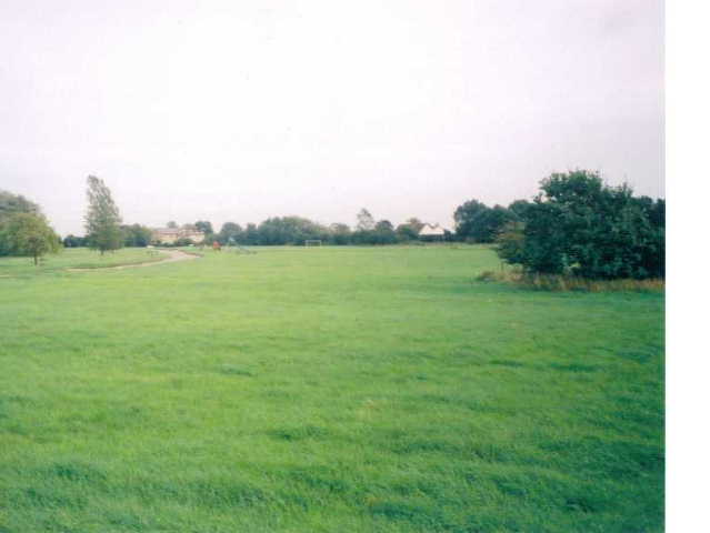
Roe Green
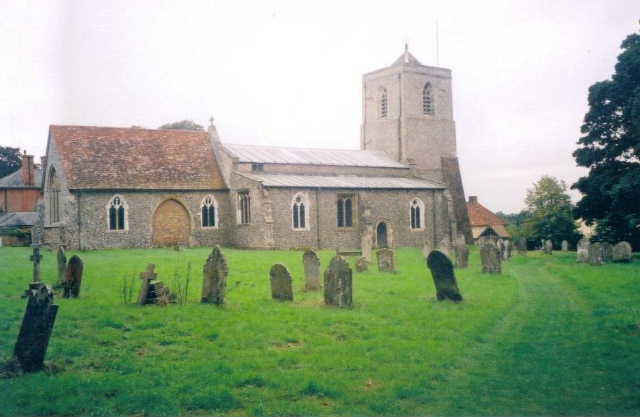
Sandon Church
I stopped for lunch at the cross in Kelshall about 1.25, and got back to the golf clubhouse in Royston about 3.30. As I then walked back up the road to the car park, I stopped and read a notice board about the fascinating history of Therfield Heath. The Heath has been used almost continuously since the every earliest times, as it contains the oldest barrow mound in Hertfordshire, about 5000 years old. There are later barrows, and evidence has been found of occupation during the iron age. A roman road ran past one end of the heath, and in the middle ages tournaments were held there. The Yorkists assembled an army there before the first battle of the Wars of the Roses at St Albans. Royston Cricket Club was founded there in about 1770 (I can’t quite remember the exact date), just three years later than the MCC, and the Militia trained on the Heath in the 1700’s. This was one of the most interesting and informative notice boards I’d come across, and I’m glad that I didn’t just pass it by at the end of my long and tiring walk.
I really enjoyed this walk. Having done some shorter walks since finishing the Chiltern Way about seven weeks ago, it felt really good to be setting out on a bigger challenge that will keep me busy for the next three months. Although it had been sunny when I set off from home this morning, by the time I reached the top of the hill at Therfield Heath it had clouded over and remained overcast the rest of the day. But this did not detract from the pleasure of the walk. There was varied scenery of heathland, woods and fields, hills to ascend and descend (a nice change after the North Bucks Way) pretty villages with attractive old houses, three churchyards with interesting old churches, and much else. I enjoyed reading the information about the new cross in Kelshall, so it wasn’t just the historical things that added to the pleasure of the walk.
Total Distance: 8.4 miles each way