Pete's Walks - The Hertfordshire Way
If you are considering walking this route yourself, please see my disclaimer. You may also like to see these notes about the maps and GPX files.
Day 15 14/11/05 Potters Bar to Goff’s Oak (7.6 miles each way)
Parked in side street in Potters Bar.
Today started out very cold – the first frost of the winter meant I had to spend five minutes de-icing my car before setting off. I also had to stop for petrol on the way to Potters Bar, so I was bit later getting started this morning, eventually setting off walking at about 10.20am. The morning soon warmed up, and after about forty minutes I took my fleece off and didn’t need it again for the rest of the day.
I probably looked a bit out of place, putting my boots and gaiters on in a smart suburban street. The walk through the outskirts of Potters Bar only took ten or fifteen minutes. After crossing a main road, I went through a kissing gate into a large pasture – this was obviously used by cows (they were absent in the morning, but had come back when I returned in the afternoon) but was also a sort of recreation area that the locals used for walks. I had a bit of a problem with the description in the guide book here, and ended up asking a chap for directions. I was thrown partly by the guide book referring to the same stile twice, making me think there were two separate stiles, and by the fact that it referred to a ‘clear path’ – it certainly wasn’t clear at all this morning!
Having passed through that field and two adjoining linked fields, I managed to find a kissing gate that led to a clear path (at last!) through the edge of a small wood. The path continued through a small area of grass and scrubland, then followed the edges of the gardens of some houses (including the imposing Northaw Place) to a junction of a lane with a road. I followed the road to the left for several hundred yards to reach the village of Northaw [1], with its pubs, church and war memorial (I missed the pond as I walked in, only noticing it on my way back). According to the guide book, Northaw is a conservation area, and has a history associated with St Albans Abbey, going back to at least 800AD.
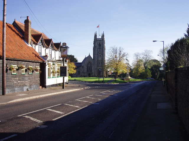
[1] Northaw
I turned left down another road and followed it for about a third of a mile. Just past the last house a footpath went right, leading gradually down hill between a fence and a hedge to the valley bottom [2]. The path bore right here to join a farm track along the valley bottom. Somewhere near here was the site of the Kings Well, a chalybeate spring (rich in iron salts) popular with James I and Charles I, but the exact location is no longer known. After three quarters of a mile, the farm track reached a road where the Hertfordshire Way turned left.
Again I found the instructions in the guide book not quite as clear as they might be, and had to ask for directions again (to be fair, I managed to miss seeing a partly obscured footpath sign from just a few feet away!). A good track led through a belt of trees and under a railway bridge. Here I turned left, then right at the field corner, over a stile and along a hedgerow to a road in Cuffley, where the station and its car park were just a few hundred yards to the left.
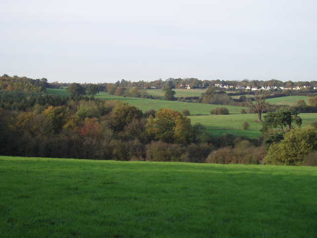
[2]View from between Northaw and Cuffley
At this point, the Hertfordshire Way splits in two, the original route (leg 10) going one way to Hertford in about twelve and a half miles, the optional additional legs 10A and 10B going a different route to Hertford that is twice as far. As usual, I want to walk every bit of the Hertfordshire Way so I will be doing both, starting with the longer route (simply because of how I could break the walk up into convenient chunks of about 7.5 miles length). Unfortunately, this leaves Cuffley by the same way as the route from Potters Bar arrives, so I had to retrace my steps as far as the railway bridge – and yes, you’ve guessed, I walked up and down the same two thirds of a mile stretch again in the afternoon! I figured I needed to do that if I’m going to say I’ve walked the whole of the Hertfordshire Way in both directions.
From the railway bridge, a very well made farm track went parallel to the railway for a while, before turning left. After about a third of a mile, I came to a crossroads of farm tracks where I turned left again. Shortly afterwards, by a farm, the track became a paved lane. After about half a mile, with good views over a valley towards Cuffley on my left [3], I turned right down another lane for a couple of hundred yards. A path on the left crossed a grass area in front of another farm, then crossed a stile into a paddock. Another stile led out of this into a hedged path, which took me to a road in Goff’s Oak. This was my turn-around point for the day, so I turned and headed back the way I came.
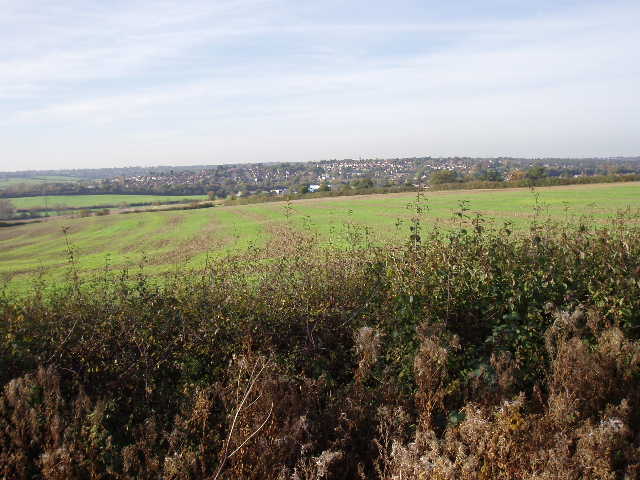
[3] Looking towards Cuffley from near Goff's Oak
After starting so cold, it was quite a pleasant day with bright sunshine and very few clouds in the sky, although it cooled a bit as the afternoon wore on. This was a very pleasant walk, a bit hillier than I’d expected. The walk through the suburbia of Potters Bar wasn’t too exciting (I just managed to get back in time to beat the hordes of marauding kids exiting a school I passed on the way!), but I suppose a walk through Hertfordshire should show all aspects of the county. Northaw was an attractive village, although there was quite a bit of road walking through it. The rest of the route was very rural – I even saw my first fox of the walk, near the site of The Kings Well on my way back. I have now turned my back on London and am heading northwards back to Royston (well, NE towards Bishop’s Stortford, then NW towards Royston). The stretch that the chap I met at Whitwell described as the least interesting part is now over, and I expect the rest of the route to get better. Not that the last few days have been too bad at all, they were nowhere near as unpleasant as I feared they might be.
Total Distance: 114.1 miles each way