Pete's Walks - The Hertfordshire Way
If you are considering walking this route yourself, please see my disclaimer. You may also like to see these notes about the maps and GPX files.
Day 3 29/09/05 Weston to Willian (6.7 miles each way)
Parked on road in Weston, near the school.
When I set out on this walk, I intended to walk a couple of miles further than Willian, to Great Wymondley, but I changed my mind part way through the walk. The Hertfordshire Way does a funny thing at Willian – the walk is basically a loop all round the county, but for some reason it goes down a near mile-long track to Willian and then turns round and comes back out of the village on the same track, adding a very short ‘spur’ on to the circular route. I originally thought that today I would walk to Willian and back on my way out, but miss this bit out on my return as I would then have already walked it in both directions. However, as I was walking along this morning I decided that if I’m to say I’ve walked the Hertfordshire Way in both directions, I need to walk up and down the track to Willian twice (I know, I’m very sad!). I didn’t fancy doing this twice in the same day, though, so decided to end today’s walk at a small car park along the track about a third of a mile out of Willian. So as not to shorten the day’s walk too much, I stopped the walk when I’d walked to Willian and then turned round and got back to the car park (hence the figure of 6.7 miles for this walk, rather than the 6.4 in the guide book) – of course, I then had to turn round, walk the third of a mile back into Willian again before turning round and walking back to Weston. An advantage of this strange behaviour is that I can start my next walk at a car park and that day’s walk will be 7.7 miles (close to my ideal of 7.5 miles) each way, to Whitwell were there is another car park.
It was another bright and sunny morning, but a lot cooler so that I put on my fleece shortly after leaving Weston churchyard – the first time I’d worn it for several months. The Hertfordshire Way took a hedged path from the church and then turned left onto a path across a ploughed field (unlike some such fields yesterday, the path had been marked out again by tractor tracks). It then passed through a small wood and across a grassy pasture. It then entered what was obviously parkland as there were large trees dotted about the grass land (although I didn’t see the great house). There were cattle in two of the fields and, rather curiously, in another there was a stile standing in splendid isolation in the middle of the field with no hedge or fence attached to either side of it. The park ended at a road, which I followed for a short distance until, after it turned sharply, I took a hedgeside path for about 800 yards. The day had warmed up a bit now and I removed my fleece. The next field contained more cows, before a short fenced path led onto the drive of a smart house that looked like a barn conversion – an ugly but friendly black dog came sniffing round my boots here. The drive led to a road, which I followed for a short distance before turning right onto a path which followed a hedge through two small fields and on to a short track. This came out onto a lane, or farm drive, opposite the ruins of St Etheldreda’s Church in Chesfield, one of the many deserted villages of Hertfordshire – all that remains of it, other than the church ruins, are a farm and a couple of isolated houses.
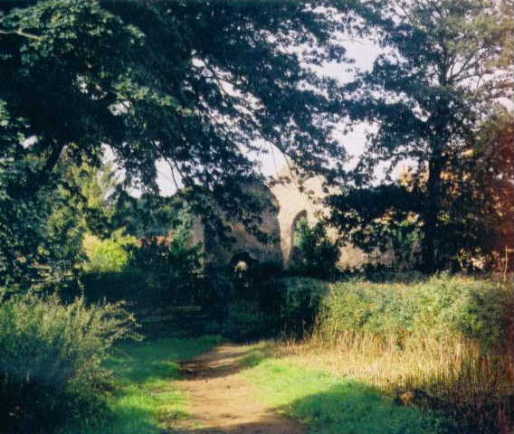
Ruins of St Etheldreda's church, Chesfield
A small section of lane walking followed, during which I saw a buzzard being ‘mobbed’ by crows. The Hertfordshire Way then followed a path along the side of a huge ploughed field, with the wide valley containing Stevenage and Hitchin ahead and to the right – the blue and white building of Lister Hospital in Stevenage was prominent in the view. After several hundred yards, at a signpost, I turned right on a path along another side of the same massive field, before following more hedgerows to reach the village of Gravely with its attractive church. The Hertfordshire Way followed a path that skirted round the edge of the village, passing a private airstrip, and then went through a fruit farm before dropping down some steps to a road (the old A1). This was crossed and a side road followed for a few hundred yards until it had passed under the A1 dual carriageway. A clear track then led right and eventually became a lane that reached Willian (which is on the edge of Letchworth) after about a mile. Here I did went through the rigmarole of walking back to the car park, turning back to the village and then turning and heading all the way back to Weston. Crazy I know, but at least it means keeping track of my distances is easy, as I will have walked every step of the route in both directions.
The walk back to Weston was very pleasant and seemed to end much sooner than expected. It grew cold again in the afternoon and I wore my fleece again, a sure sign that summer is over and autumn has arrived.
Total Distance: 22.8 miles each way