Pete's Walks - John Bunyan Trail
If you are considering walking this route yourself, please see my disclaimer. You may also like to see these notes about the maps and GPX files.
Day 1 4/12/06 Sundon Hills Country Park to Harlington (8.2 miles each way)
Parked at Sundon Hills Country Park.
I thought this walk would be somewhat frustrating – from the start point at the Sundon Hills Country Park I could see my destination at Harlington about a mile and a half away, yet I was going to have to walk eight miles to get there. However, it turned out to be such an enjoyable walk that I didn’t mind having to go such a long way round. The weather played a part in the enjoyment of this walk – I had clear blue skies and bright sunshine for most of the morning, but when I turned round at Harlington I was soon overtaken by dark grey clouds and the skies quickly became overcast. This meant it really was a walk of two halves, with a complete contrast in atmosphere and conditions between the morning and afternoon. I enjoyed having the opportunity to see everything along the route both in bright sunshine and in the gloom of a grey December afternoon.
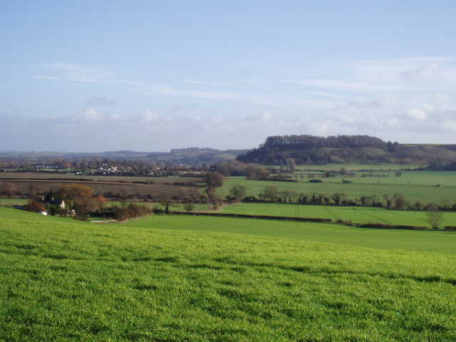
I had walked the first two or three miles of this route twice before, on the Chiltern Way and more recently on the Icknield Way section of my Berks-Essex walk. In a recent journal entry I said that I enjoyed walking a route a second time, but not a third. As usual, I was talking nonsense – it obviously depends on how enjoyable the route is. Here, I was actually looking forward to walking this section again, and having done it a third time would be quite happy to walk it again. It is a very enjoyable walk as it goes along the top of a steep escarpment, generally with very good views over the lower ground to the north. Parts of the walk are through woods, restricting the views but giving variety and interest to the walk.
[1] Sharpenhoe Clappers from the Sundon Hills Country Park
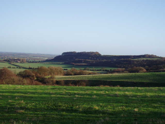
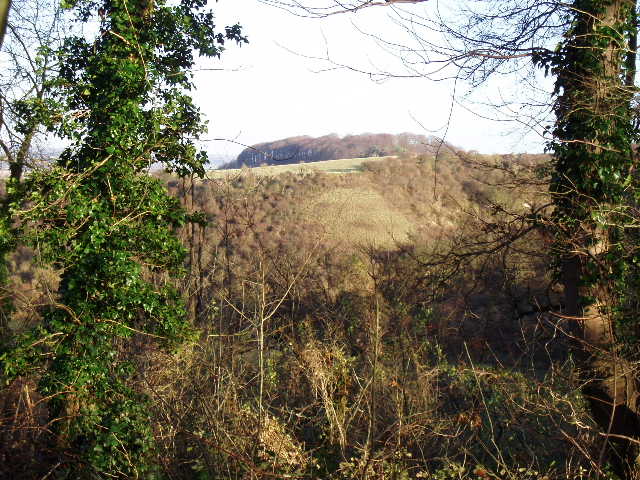
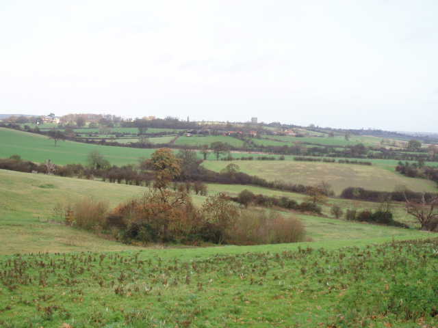
[2] Harlington and the Greensand Ridge beyond, from Sundon Hills Country Park
[3] Waymarks at Sundon Hills Country Park
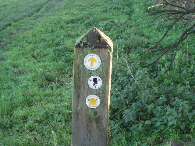
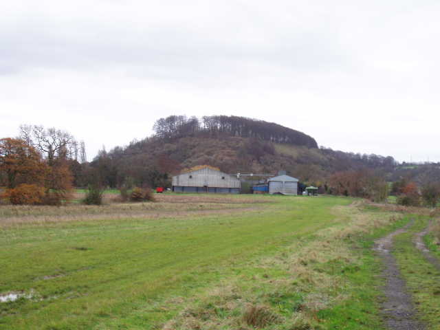
I started walking about 9.35am. From the car park at the Sundon Hills Country Park, I went through a kissing gate and started following a hedge on my right in a north-easterly direction. This was a very large grass field, grazed by a flock of sheep, which sloped down steeply to my left. There were lovely clear views in the bright sunshine towards Sharpenhoe Clappers ahead of me [1] and over the lower lying land to my left [2]. I could see my destination at Harlington, and the distinctive landmark of the water tower at Pulloxhill that I would also be walking past. Although very good, the views were nowhere near as extensive as those from other escarpments I’ve walked such as Dunstable Downs, Ivinghoe Beacon or Combe Hill, as they were limited by the greensand ridge which runs a few miles north of here – I picked out Ampthill and a few other spots I recognised from my walk on the Greensand Ridge Walk earlier this year. About halfway across this large field I passed a post with waymarks for all three paths that go through here – the Chiltern Way, the Icknield Way and the John Bunyan Trail [3]. There seem to be two types of waymark for the John Bunyan Trail, both black on a white background, the first being a simple arrow and the second having a silhouette of Bunyan’s head. Curiously both bear the lettering ‘The Bunyan Trail’ rather than ‘The John Bunyan Trail’ – it is marked John Bunyan Trail on the map and that is what it is called everywhere else.
[4] Path heading towards Sharpenhoe Clappers
[5] Sharpenhoe Clappers, glimpsed through the trees along the path from Sundon Hills Country Park
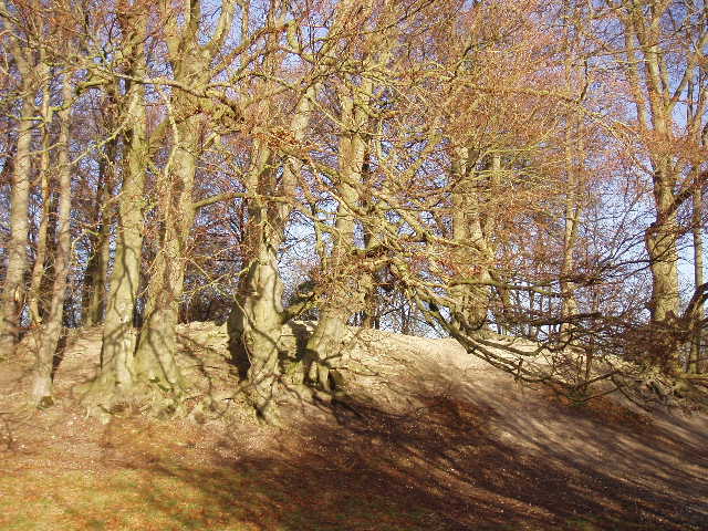
[6] Beech trees on the edge of Clappers Wood at Sharpenhoe Clappers
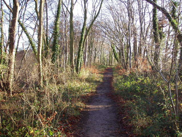
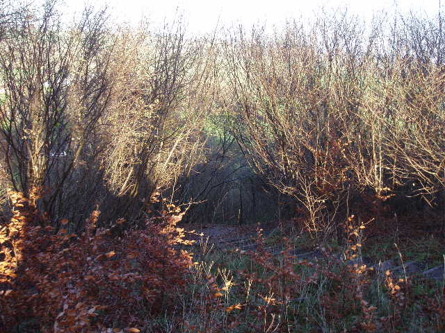
At the end of the field, I went through another kissing gate and followed a track that curved round the end of a deep combe cut into the escarpment. I then turned right onto a footpath, that followed a left hand hedge for a few hundred yards, and at the next field corner I turned left with a wood on my right. I soon came to another path junction where I turned left with another wood on my right, and I followed the path as it turned right alongside the wood. I continued alongside the edge of the wood for several hundred yards before reaching a field corner, where the path turned left for a few yards before turning right and entering the trees. Although I had now lost the good views, this next section was very pleasant as the path continued through the trees along the top of the steep slope to my left [4]. This went on for about half a mile, with occasional glimpses through the trees towards Sharpenhoe Clappers [5]. Eventually I went over a stile on my right and crossed a grassy field to a road, and the Sharpenhoe Clappers car park beyond.
Sharpenhoe Clappers is a promontory projecting from the long chalk escarpment of the Chiltern Hills, now capped by a circle of Beech trees [6]. It was once the site of an iron-age hill fort and is a landmark for miles about. I followed the well-worn path from the car park to the top of the Clappers (the Icknield Way bizarrely turns off right before reaching the Clappers) and enjoyed walking amongst the beech trees there. A small monument with a plaque commemorated how Sharpenhoe Clappers was purchased by the National Trust through a bequest of W.A.Robertson [7]. Mr Robertson bequeathed over £50,000 to the National Trust in 1935 as a memorial to his two younger brothers killed in the First World War, and eight areas of countryside and Sutton House in Hackney were purchased as a result. Robertson Corner, part of the Dunstable Downs near my home in Kensworth, was another of these purchases and there is a similar memorial by a road junction there. Another purchase was part of the Devil’s Punchbowl in Surrey.
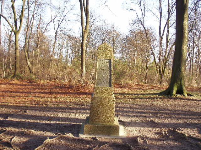
[7] The Robertson memorial in Clappers Wood
[8] Start of the steps down from Sharpenhoe Clappers
[9] Looking back towards Sharpenhoe Clappers from just past Bury Farm
From the top of the Clappers I took a path heading north, descending the very steep slope on a flight of wooden steps [8]. I was now on the route of the northern extension of the Chiltern Way, the original route bearing right from the Clappers towards Streatley. Where the path left the trees, I continued down the hillside along a left-hand hedge to reach a road where I turned left into the village of Sharpenhoe. After a short distance I turned right, opposite the village pub, to go down a private drive to Bury Farm. I went across the concrete farmyard and continued northwards on a good farm track [9]. Where I met a crossing hedgerow, the northern extension of the Chiltern Way turned right towards Barton, but I continued ahead on the farm track, now entering unknown territory. I was crossing a very flat area of land, with the steep chalk escarpment behind me and a low ridge of hills ahead of me – the large concrete water tower at Pulloxhill was prominent on the skyline, and that was were I was heading [10]. Just beyond the next field corner, I turned left over a footbridge over a drainage ditch and a few yards further on left through a gate in another hedge.
[10] Farm track heading away from Sharpenhoe towards Pulloxhill
large grassy field – there was no visible path, but from the map I could see that I had to walk in the direction of a large farm I could see on the hillside in front of me. Having gone over a slight rise, I could see a fence ahead of me with a kissing gate. I then had to head towards a corner of the next field, which contained various types of cattle – most of them congregated round the kissing gate I needed to go through. I noticed a large black bull amongst the cattle, but had no difficulty getting through them and through the gate. The next field also contained a few grazing cattle, as I turned half right towards another gate, marked by a yellow post. The farm I’d been walking towards was now on my left, about halfway up the hillside. Beyond the yellow marker post I continued through two or three more fields alongside a hedge or fence on my right, as the path rose almost imperceptibly across the hillside – I could see gates and stiles that marked the route of a parallel path a couple of hundred yards to my left. My path then ran between hedges for a while, before following a left-hand hedge as it turned and climbed more steeply up the hillside. It joined a track with some dwellings on the right, before reaching a lane opposite the impressive water tower at Pulloxhill [11]. 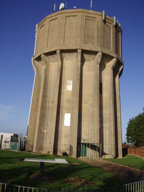
[11] Water tower at Pulloxhill, a prominent landmark on several stages of the John Bunyan Trail
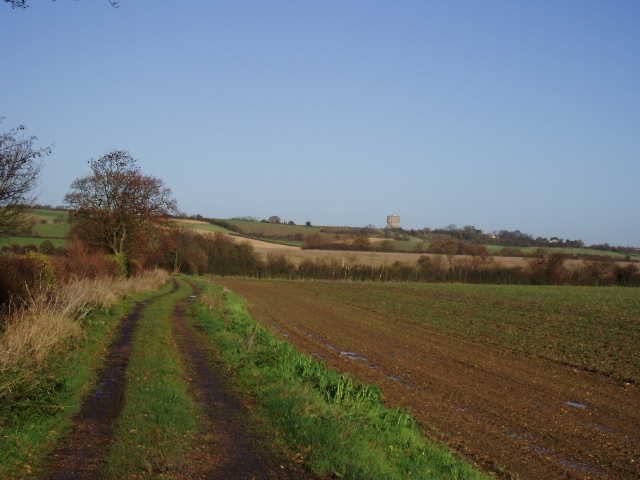
Here I turned left along the lane, and followed it south-westwards for about half a mile. Although I was walking on a tarmac surface, this section of the walk was still very pleasant as it followed the crest of a small ridge so, where the hedgerows allowed, there were very good views to both north and south. Northwards I could see over the valley of the river Flit to the greensand ridge, with both Flitwick and Ampthill clearly visible [12]. To the south I could see across the flat ground I’d just crossed back to the long chalk escarpment of the Chiltern Hills. Where the lane came to an end, I turned right for a couple of hundred yards down a drive, before turning left to continue south-westwards on a bridleway. This ran between a hedge and a boundary wall of Higham Bury on my left. It then briefly entered the parkland of this large house, before going through a gate and following a left-hand hedge, still with nice views towards Flitwick and the Flit valley. The path went downhill slightly, following the edge of a large field of cabbages or similar crop, than became a broad track running between hedges (where I saw two Jays on my return trip).
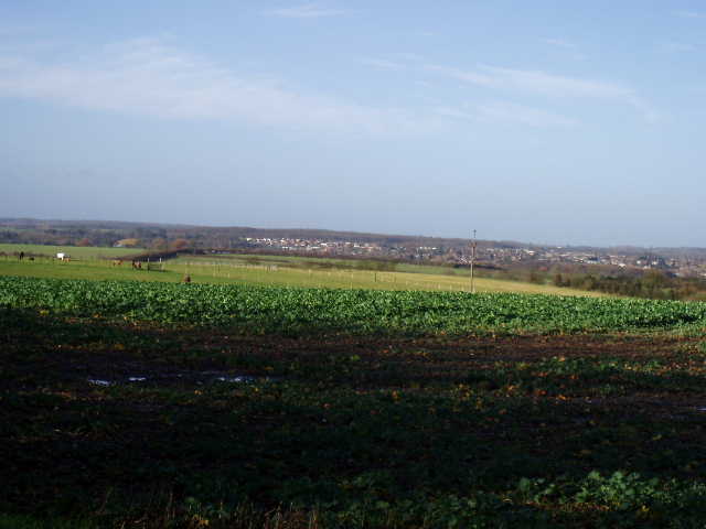
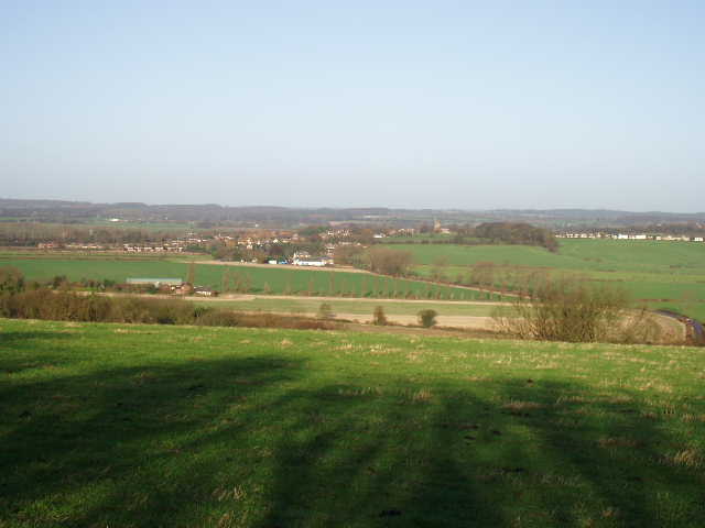
[12] View towards Flitwick and the Greensand Ridge, from near Pulloxhill
When the path emerged on a tarmac drive leading to some farms, I turned left and followed it for about a third of a mile to Upper Samphills farm, where I turned right on a footpath. This went downhill across a large green meadow, across a rather slippery stile, through some scrubby bushes and over another stile (where I had my lunch on my return). The path then crossed an arable field – the path had been cleared and was easy to follow, but was very muddy. The John Bunyan Trail then followed a left hand hedge for a few hundred yards, before entering a very large grassy field, which sloped up quite steeply to the corner of a wood on the edge of Harlington. When I reached the stile into the wood, I followed the instructions in the print-out and looked back – I could see an old dead oak tree with a sapling planted by it – the tree was Bunyan’s Oak, where the great man had often preached [13].
[13] Looking back towards Pulloxhill from the edge of Harlington (remains of Bunyan Oak just visible on left)
[14] View back to Sharpenhoe Clappers from Harlington
I crossed through a corner of the wood to reach a road and turned right into Harlington. The houses were only on the right side of the road here – to my left was a lovely view over the valley to the Chiltern Hills. In particular, there was a lovely view of Sharpenhoe Clappers jutting out from the escarpment, with the Barton hills beyond it [14]. Where the road turned sharply right, I continued ahead across the large village green, with a pond and then the church on my right [15,16]. Harlington church dates from the fourteenth century, although the tower was not built until a century later. According to the print-out for the John Bunyan Trail, the church contains a stained glass window showing scenes from Pilgrim’s Progress and an altar table supported by part of the Bunyan oak tree. I noticed that the tower, if not the entire building, were built from green sandstone, which I recognised from many churches and other buildings that I passed on the Greensand Ridge Walk. I turned left to a road junction [17]. Opposite me was Harlington Manor, where Bunyan was questioned and imprisoned after preaching in a local house – the building is now a health club. I turned round and followed the road back past the church, and then turned left along a footpath that led through a sequence of alleyways through a housing estate to a road on the northern edge of the village.

[15] Pond, by the green in Harlington
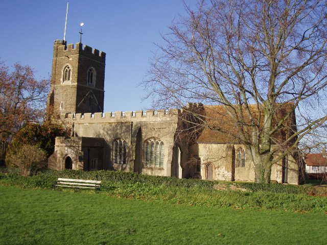
[16] Harlington Church
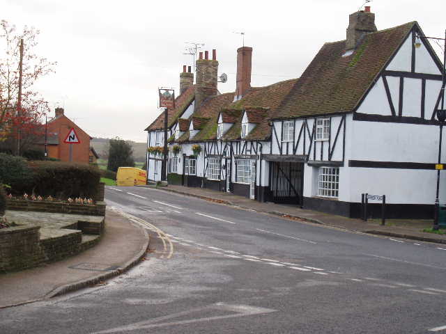
[17] Harlington
It was as I turned round here that I became aware that the western half of the sky was now full of grey clouds – the forecast had said that rain would be arriving about four or five o’clock, I hoped it wasn’t going to be early. Shortly after having my lunch, the grey clouds overtook me and there were a few spots of rain – it looked like I could be in for a soaking, but fortunately there were just a few drops for two or three minutes. I could see the remaining area of blue sky gradually disappear eastwards, and soon the whole sky was grey and overcast, but it remained dry for the rest of walk (and my drive home). As I mentioned before, I found it an interesting contrast to walk back in the grey and gloomy light of a dark December afternoon, compared to the bright sunshine of the morning.
This was a very enjoyable walk (it would be easy to turn it into a 10-mile circular walk by taking paths south from Harlington back to the Sundon Hills Country Park). It was much better than I’d expected – I couldn’t really see the point of going all the way out to Pulloxhill (it doesn’t seem to have a Bunyan connection), but the walk along the ridge of hills to Harlington was very good because of the extensive views in both directions. I will be very happy if the rest of the John Bunyan Trail is as good as this!
Total Distance: 8.2 miles (each way)