Pete's Walks - The Chiltern Way (2)
If you are considering walking this route yourself, please see my disclaimer. You may also like to see these notes about the maps and GPX files.
Day 18 16/05/07 Sonning Common to Whitchurch Hill (7 miles each way, approximately)
Parked at Millennium Green at Sonning Common.
This was my first walk on the Chiltern Way for two weeks, as I spent last week on holiday walking in the Lake District. My luck with good weather there seems to have run out, as this was the third successive holiday in a row there when I’ve picked a very wet week. Still, my friend Martin and I managed to do a walk of some sort every day, and I visited a few lesser peaks that I’d not been to before (Souther Fell, Barrow, Outerside, Ladyside Pike). I also went over a few peaks that I’d only been to once before, and that a long time ago, such as Beda Fell, Wandope and Whiteles Pike.
I left home earlier than usual, and so managed to start walking about 10 O’clock despite the drive taking an hour and 20 minutes. The weather forecast had predicted a cloudy day, but the skies had brightened considerably during my drive, and as I set off walking the skies were largely blue and I regretted leaving my sun-hat at home. I parked in the small parking space for the large Millennium Green at Sonning Common, and started by following the gravel path across the green to the corner I reached at the end of my last walk. Here I continued on along the path as it turned right, before going through a red wooden gate in the hedge on the left. I turned right along a lane for a few yards to a T-junction, where I turned left along a minor road. After about 100 yards I took a footpath on the right, which crossed a very large field – this seemed to consist of a mixture of oil-seed rape and some other crop that I’ve seen before but don’t know the name of [1]. As the path dipped slightly and rose again it passed near to a copse on my right – I saw a Buzzard here, and was surprised that it stayed around rather than fly off as I went close by.
On the far side of the field, I went over a stile in a hedge and followed a left hand wire fence through a small pasture containing white cattle, with a farm a short distance to my left. I crossed another stile and went across a small empty enclosure. Over another stile, I followed a path to the left through scrub, then a further stile gave access to a garden which I crossed to reach a lane in the small village of Chalkhouse Green. Here I followed the lane to the right, continuing ahead at a junction. Just past the last house on the left, I turned left into a wide track called Dysonswood Lane. This descended slightly at first, then turned left, running between hedges along the valley bottom [2]. It was muddy in places (it’s been wet here in the south as well as up in the Lake District), but stonier as it turned right to climb the other side of the valley. It soon became tarmac where a drive came in from the left, and led me to the next village, Tokers Green.
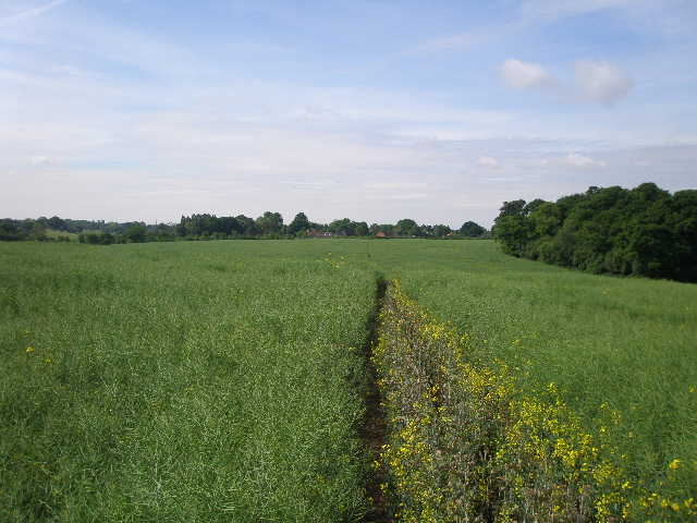
[1] Path leading away from Sonning Common towards Chalkhouse Green
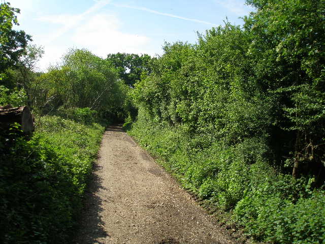
[2] Dysonswood Lane, between Chalkhouse Green and Tokers Green
[3] View from just past Rose Farm
Here I turned left and then almost immediately right into Rokeby drive. I followed this for about half a mile – it is mainly residential, but at one part there is a golf course on either side. Where it ended at a main road, I crossed over and went a few yards to the right to a footpath sign. The path now crossed an arable field – I was glad that the path was clear, as two years ago this had been the only field on the entire Chiltern Way where the path wasn’t clear and I’d had to fight my way through a field of head-high maize. On the far side, I turned left along the edge of the field with a wood on my right. In the corner of the field I went through a hedge gap to a road where I turned left, with more woodland on my right. After a couple of hundred yards I turned right on a footpath descending slightly alongside the wood. I soon had another golf course over the hedge on my left. Leaving the wood behind, the path went slightly uphill between hedges to a crossroads of tracks, where I turned left. The driving range of the golf club was now on my right, with the actual course on my left. The skies had now clouded over, and I no longer worried about leaving my sunhat behind – instead I worried that the grey clouds might bring some unforecast rain.
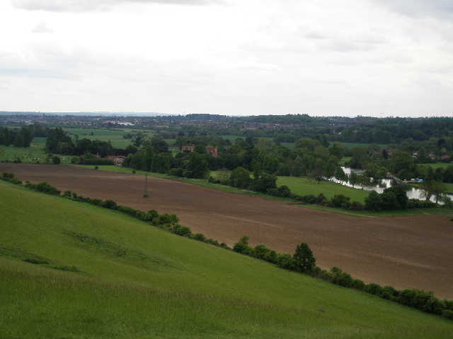
At a junction, I turned right along another track, which soon brought me to Rose Farm. A modern-looking small granary here was raised on old staddle stones, which were designed to prevent rats reaching the grain. I followed the concrete farm drive, bearing slightly right to a junction with another drive [3]. Here I went ahead on a path across a grass field to reach some woodland. The path continued a short distance between mainly young beech trees, then descended slightly as it went left in a more open area where views opened over the Thames Valley. The path then contoured round the hillside through bushes and trees [4], until it reached a folly (a statue on top of a tall brick column, presumably an ‘eye-catcher’ associated with the nearby Mapledurham House) [5,6]. Here the path descended quite steeply to the left, then passed through a gate to emerge in a field where a large herd of black and white cows were to my right. Across a stile on the far side, I turned right along a concrete farm track to reach the sole lane that enters the charmingly attractive village of Mapledurham.
[4] Contouring path through bushes, heading towards Mapledurham
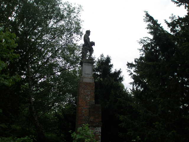
[5] The folly, near Mapledurham
[6]View over Mapledurham and the Thames valley from the folly
I turned left, off the route of the Chiltern Way, to take a quick look at the village. I passed some almshouses (converted into two cottages) on my right that date from 1613 [7], and soon reached the end of the lane, with Mapledurham House to my left, St Margaret’s church in front of me and the watermill to my right [8]. The house [9] has been the home of the Blount family and their descendants since 1490. Part of the house is fifteenth-century, but most of it is built of red-brick dating from 1585-1588, with nineteenth-century alterations. The house was visited by Elizabeth I, and is mentioned in John Galsworthy’s Forsyte Saga (it is Soames Forsyte’s home). The church dates back to the late 13th century, and contains a private Roman Catholic chapel belonging to the Blounts. The watermill is the oldest one on the river Thames, and the only one to still be working (my parents’ neighbour Tony was brought up in the village, and remembers taking corn to the mill to be ground into flour). There was a mill here at the time of the Domesday Book, but most of the current mill dates from the fifteenth century, with additions in the 1670’s and around 1700. The mill features in the 1976 film The eagle has landed and on the cover of a Black Sabbath album. The whole village still belongs to the Mapledurham estate, which have not allowed any new development for over a hundred years, which is one reason why the village retains its old-world charm. The idyllic and isolated riverside setting also adds to its attractions.
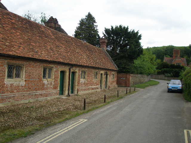
[7] Former almshouses in Mapledurham
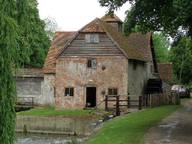
[8] Water mill in Mapledurham
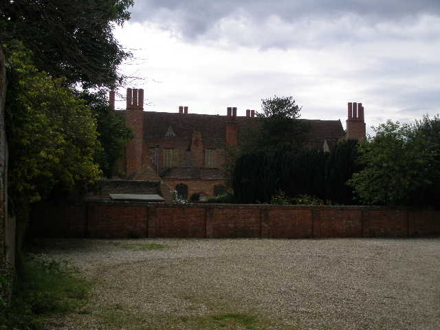
[9] Mapledurham house
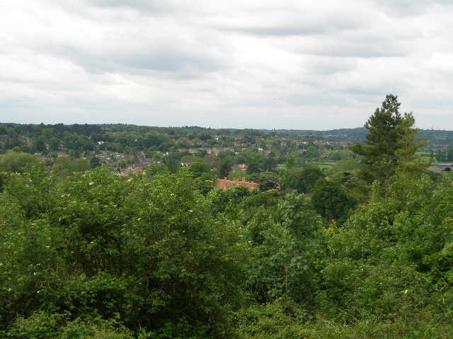
I turned round and walked back to where I entered the village, and continued along the lane for a few hundred yards. I then turned left along a bridleway between hedges, with fields to my left and a steep hillside on my right. There were several types of wild flower along this path, including some Cut-leaved Cranesbill. After about a third of a mile, I went through a kissing-gate on the right into a large meadow, where I followed a path going very steeply up the hillside to reach the edge of a wood. Here I turned to admire the view back over Mapledurham and the Thames Valley [10,11]. Once inside the wood, I wasted a few minutes deciding which fork in the path to take (neither the map nor the guide book were very clear). After a little exploration I realised I needed to take the right fork, which descended briefly through the trees before turning left and contouring round the hillside, to the right of the summit. The path soon joined a wider track that continued ahead, now descending gently through the trees to a valley bottom and a crossroad of paths. The Chiltern Way continued ahead, rising uphill on a muddy track, soon emerging from the trees beside a cottage in the hamlet of Collins End.
I followed a fenced path between paddocks to reach a lane. I passed a few cottages on my left, then turned left on a track between two properties. I climbed over a gate and followed a right-hand hedge through an overgrown field, then went over a stile in the hedge and continued along the other side, descending slightly in another grassy field. Over another stile, I continued descending through some scrubland close to a wire fence on my left. Near the valley bottom I emerged into a large pasture, with some cattle way over to my right. The path went straight down the last few yards to the valley bottom and straight up the other side, to enter a small copse and reach a lane beyond. Here I turned right into the hamlet of Path Hill.
[10] Looking back across Mapledurham and the Thames valley, from the edge of the wood
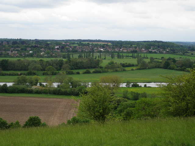
[11] Looking across the Thames valley from the edge of the wood
[12] Field path leading towards Whitchurch Hill
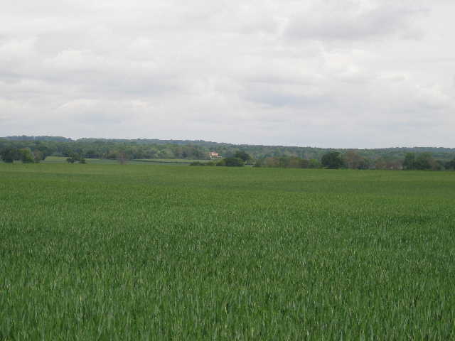
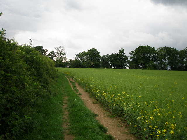
I soon reached a junction, where I went left. After a few hundred yards between the scattered dwellings of the hamlet, the lane started to descend and I turned right off it, following a drive past some cottages to reach a meadow. The path through the meadow kept close to the right-hand hedge to reach a stile in the corner. I went left along a track for a few yards, with views ahead to the Thames valley, then turned right alongside the left-hand hedge of another field of that strange crop that I don’t know the name of [12]. The hedge soon ended and I continued on a wide path through the crop – I saw a deer here bound away through the crop, and on my way back a fox crossed the path about 20 yards in front of me. I only got a glimpse of the deer, but I think it might have been a Red deer – if so, it would be the first I’ve seen in the Chilterns.
The Chiltern Way now continued on a good farm track – I saw my first Scabious of the year growing here. Shortly after passing a small wood on my left, I went through a kissing gate into a large meadow. This was a nature reserve, recently planted with wild flower seeds – there were many Ox-eye daisies here. I crossed the field diagonally to a metal gate, and passed in front of a row of houses to reach a road by the green in Whitchurch Hill. I crossed the road and the parking space beside the green, then turned round and headed back. (Note: I have reduced the length of this walk by 0.2 miles from the distance given in the guide book, as that measures as far as the village church. As I will be parking here by the green on my next walk, it seemed pointless walking the short distance from here to the church on both walks).
It started to spit with rain as I turned round (about 12.45). When I stopped to eat my lunch in the wood between Collins End and Mapledurham, it became a bit heavier and I put on my lightweight rain jacket. I kept it on all the way back to Sonning Common, as it drizzled on and off – it rained quite heavily for the last half mile or so.
This wasn’t a bad walk at all, with a good mix of woodlands and fields, and views over the Thames Valley. The highlight was undoubtedly Mapledurham, which rivals Hambleden as the most attractive village on the whole of the Chiltern Way. Unfortunately I just couldn’t seem to work up much enthusiasm today – I felt like I was walking for the sake of it, rather than because I wanted to. Strange, as I’d been looking forward to it yesterday. Perhaps it was because of the grey and muddy conditions, such a disappointment after the wonderful walking conditions I had last month. (Apologies that my lack of enthusiasm is reflected in the quality and quantity of the photographs I took during the walk)
Total Distance: 132.8 miles each way