Pete's Walks - The Hertfordshire Way
If you are considering walking this route yourself, please see my disclaimer. You may also like to see these notes about the maps and GPX files.
Day 8 27/10/05 Redbourn to Jockey End (7.8 miles each way)
Parked by church in Redbourn.
This was a very pleasant walk on a glorious autumn day – the warmest October 27th for 117 years, according to the radio. The temperature was about 20C, and there were clear blue skies all day – the wind picked up a little in the afternoon, but this just served to keep me cool.
I have twice this year walked from my home in Kensworth to Redbourn and back, going via Markyate and Flamstead. There are effectively three routes between Markyate and Redbourn, roughly parallel – I have used the outer two paths, so I was pleased to see that the Hertfordshire Way mainly keeps to the central route that I have not previously walked. Being so close to home, though, it was inevitable that I would have walked some of today’s route before.
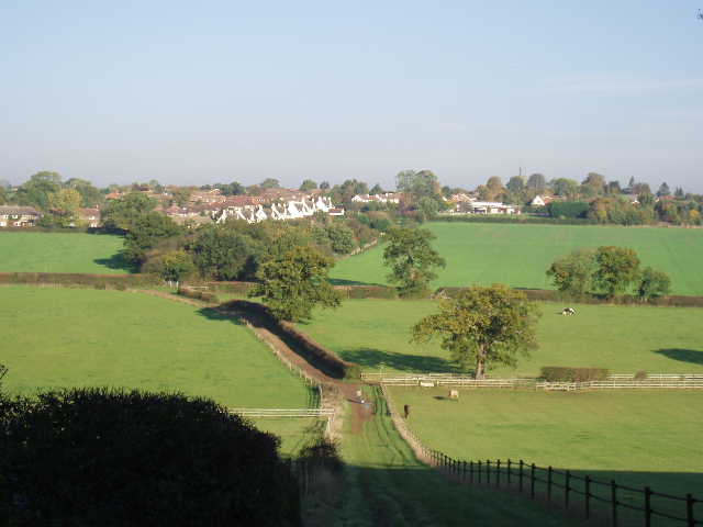
[1] Looking towards Flamstead
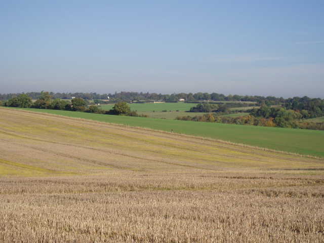
The Hertfordshire Way passes through the churchyard at Redbourn, then follows a field boundary alongside the backs of some gardens before crossing the field (beside a row of telegraph posts) to reach the tarmac drive to Flamsteadbury farm. It follows the drive left, crossing a bridge over the M1. Beyond the farm, it continues as a clear farm track for almost a mile – there are huge arable fields on either side, as no other field boundaries are crossed in this distance. When the track eventually reaches a corner of a lane, the Hertfordshire Way turns right down a bridleway for a quarter of a mile, before turning left on a footpath. This crosses an arable field to a hedge where it turns right. Soon good views of Flamstead appear across a small valley [1]. As I reached the bottom of the valley I came across a man with presumably his grandson, the child moving a stick about in a deep puddle. “Hello, we’re fishing for Alligators.”, the man said. “Any luck?”, I replied. “Not Yet”. “Is it the right time of the year for them?” I queried.
A footpath turned off to the right and led through trees to the edge of Flamstead, where I turned right up the main road to pass the church [2] and the village centre. Near the church, the Hertfordshire Way shares its route with the Chiltern Way for a few yards. Flamstead always seems a very pleasant village to me when I walk through it, with plenty of old houses to give it some character. The church tower is topped with a ‘Hertfordshire spike’, a sort of spire in miniature (I’d have thought the inhabitants of wealthy Hertfordshire could afford the real thing!). Thomas Pickford, the founder of the removals firm, is buried in the churchyard here.
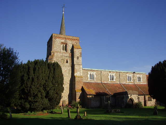
[2] Flamstead church, with its 'Hertfordshire spike'
The route out of Flamstead was down the curiously named Friendless Lane. The Hertfordshire Way then took a footpath on the right, crossing a couple of paddocks and then some more large arable fields, all the time along close to the crest of a hill running parallel to the river Ver (over to the right in the valley bottom). This was a very enjoyable part of the walk, with pleasant views over the valley towards the parish of Caddington [5]. After about a mile and a half, the path descended gradually alongside some allotments to reach the village of Markyate [3]. This is probably best known for Markyate Cell, an impressive house associated with Katherine Ferrers, the reputed highwaywoman whose life inspired the classic film ‘The Wicked Lady’.
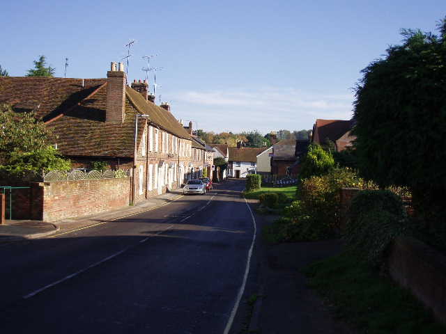
[3] Markyate
From the centre of Markyate I took Buckwood Road (a route back to my home in Kensworth) and at the end of the houses I turned left. Shortly afterwards I came to a path junction – I knew both paths ended up at the same point, one going there in a straight line, the other in a ragged sort of semi-circle. Curiously the Hertfordshire Way took the longer path, which was also slightly steeper and partly followed a hedge bordering houses. Personally I would have thought the other path a better choice of route. Where the two paths rejoined (about half a mile on along the longer path), a stile led on to another hedgeside path which led to Roe End Lane. I turned right along the lane, and when it ended after about a quarter of a mile, I turned left along a clear farm road. This descended a valley and rose the other side, with a field to the left and wood on the right. After half a mile I came to a crossroads of farm roads, with a farm on my right. I turned left, and after a few hundred yards passed in front of the imposing façade of Beechwood School [4]. According to the Hertfordshire Way guide book, this grand house was built on the site of a nunnery, which after the dissolution of the monasteries by Henry VIII became a Tudor mansion. Henry’s son Edward VI once stayed there. It became a school in 1964.
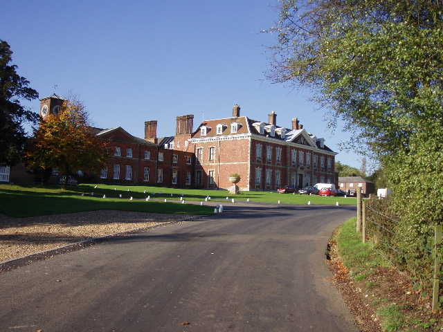
[4] Beechwood School
The Hertfordshire Way turned right and passed beside the school playing field. It then crossed a field downhill, to a bend in a lane. Here it turned right along a bridleway called Dean Lane, where I met four horse riders coming the other way. After a third of a mile, a footpath on the left crossed a field and then a small playground to reach a road on the outskirts of Jockey End, the main settlement in the parish of Gaddesden Row.
[5] View towards Caddington, from path between Flamstead and Markyate
On the way back, I found a quiet spot to eat my lunch in Markyate. I really enjoyed the walk back to Redbourn, enjoying the widespread views on a gloriously sunny afternoon. I’ve thought about this a couple of times lately – I’m sure many people who read these journals must think it strange that I walk 7-8 miles in one direction and then turn round and walk exactly the same route back. I do it out of necessity, walking by myself and going to remote places where public transport isn’t really feasible, but I’ve quickly got used to it and enjoy it. The walks back seem to pass quicker, mainly because I don’t have to worry about navigating, and I enjoy seeing the scenery from a different direction. It also means that these long-distance paths are twice the challenge, which after all is a major reason for doing them in the first place.
Total Distance: 60.9 miles each way